
 A steady snow fell and added to the layer that already coated the roadway. After a short orientation for my new job at the ski area, I was headed down to the city, my progress thwarted by a cautious driver who restrained her automobile on the downhill grade. Eager to get moving and unfazed by the fresh accumulation, I roared to let my little Suburu rip it. Then as now, the roos identify the mountain man or woman within.
A week before the Thanksgiving opening date, the storm foretold what would be judged as an epic ski season five months later. Stuck behind the car with Pennsylvania plates I cursed and did not celebrate yet.
But today I do rejoice. The contentious introduction yielded a lasting friendship with Nan, one that survived after we both left Santa Fe. She once again calls the Philadelphia area home, and I surmise that she has reclaimed the PA plates that she had relinquished only reluctantly. Today we both crouch under low ceilings, squeeze between narrow mineral formations and squint in the dim underworld of the Sierra Nevada foothills.
After plans to secure inexpensive flights to visit Québec and New England failed, we switched our goals and Nan flew west instead. Attempts to cash frequent flyer miles in returned circuitous routing and grotesque schedules with overnights in Cincinnati or Atlanta. Just before midnight yesterday, Nan landed in a typically busy LAX. After breakfast at the Urth Caffé terrace in West Hollywood, we ditched the Los Angeles sprawl and Central Valley plainness for the majesty of Sequoia National Park.
We are following a competent and jocular guide into the inner recesses of Crystal Cave, discovering the unique charms of soda straws, popcorn, cheese, melts, curtains, stalactites and stalagmites and unpronounceable names. We signed up for the 4 p.m. regular visit and not the longer Discovery Tour because I had not interpreted “tours offered Monday, June 25 through Friday, August 31, 2007” to indicate that there are no tours on weekends. Never mind that I had phoned the park to inquire about my chances of scoring tickets.
Crystal Cave sits 400 meters beyond the end of a windy road. To avoid unnecessary travel, park management sells tickets at the visitor centers instead.
“It takes two hours to reach the cave if you don’t make any stops” explained a ranger at the Foothills Visitor Center.
“Two hours??” I blurted out, incredulous. “How far is it?”
He hesitated a bit and estimated the distance at 30 kilometers. Even with construction delays on the tortuous mountain road, we managed to indulge in a 20-km side trip to Lodgepole and still showed up with time to spare. The same pessimistic ranger did not know about the “Dinner with a Ranger” program but called the Lodgepole Market that confirmed a barbecue did take place every evening and that we simply had to buy our tickets ahead of time. Whoever answered the phone failed to mention that space is limited, a vital tidbit that the Russian cashier shared with us immediately.
“We sell out everyday around 2:30.”
 Even as she breathed hard to hike back up from the cave, inhaling more than she wished of what she identified as deleterious witch hazel, I persuaded Nan to accompany me to the top of Moro Rock. The granite monolith tops out at 2,050 meters, floating free from the confines of the dark forest of giant trees. Surprising views unfold during the short climb to the summit. Mount Whitney looms beyond the obstruction of the Great Western Divide and Nan snapped a few pictures when I became animated at the realization. It was during this last week of August two years ago that I climbed it. It was also a year ago this time that Eric and I bounced around Northern Arizona. I can’t remember where I was three years ago, but this has the hallmark of a tradition, what says you? Sadly, Eric-tinged memories will be even more spaced out now that he has left the country and returned to Europe. I don’t blame him, but it reduces my opportunities to hike. And to see him.


 Nan hungered to hug a sequoia and we spotted this dead specimen for her to go wild. Note that she is not unusually small. It’s them roots that are quite large!
  Dusk arrived and we commandeered a picnic table and improvised a “Dinner without a Ranger” at Stony Creek, a campground sandwiched between Sequoia and Kings Canyon’s Grant Grove. In the dark I could not find the exit of the damned place and Nan, shamed, hesitated to ask for, uh, directions.
Unbelievably, I ended up in Fresno for the second time in three months. I picked another Motel 6 to hole up, not far from the one with the beached sailboat. We were greeted like potential criminals, forced to check in without entering the lobby and conversing with the attendant through a plate glass window from the coziness of the parking lot. She encouraged us to phone in for a survey: for each 100 replies, she earns $10.
Retracing my steps with Patricia from early June, we arrived in Yosemite Valley late morning. Half Dome is where we left it, but Yosemite and Sentinel falls have dried up. Mark, one half of the pair who offered me a ride from Glacier Point to the valley when I was here last, will be back in the park with his two daughters mid-September. I so wanted to hide a memento of some sort on a nearby trail, but got distracted having lunch at a table with a Montreal couple who delighted us with climbing stories and Québecois accents. In late afternoon they were to set out for a three-day journey up El Cap’s Zodiac line.
Sinister skies had gathered over the spine of the Sierra Nevada when we reached the high country. The rumble of thunder bursts and lightning strikes punctuated our walk around Tuolumne Meadows. We neared the base of Lembert Dome but declined to scale it, half expecting a direct hit on this exposed hunk of granite. No trip on the Saddlebag Lake water taxi to the Mount Conness Glacier either!
 Laden with ozone, the air smelled richly near Tioga Pass. We spotted hail on the ground when we stopped to take this picture of Dana Meadows. It felt positively wintry, a sensation confirmed by the car’s thermometer that registered 9°. Knowing how Patricia and I endured an early June snow squall at nearby Greenstone Lake, but within minutes traded snow flakes for warm sun at the bottom of the pass, I pronounced boldly that the temperature would improve to 30°. Nan smelled a financial opportunity and agreed to my wager.
 The car dipped quickly toward Lee Vining at Mono Lake’s edge. I kept an eye trained on the temperature gauge and another, more judiciously, on the plummeting road. Hope as I might, my fortune evaporated: It barely registered 20° once we hit US 395 at the foot of the mountain and I contemplated signing my wealth over to Nan.
“I think I owe you five bucks …” I abdicated.
And almost missed the turn off for the Mobil filling station where we fed ourselves (“A most surprising deli” remarked Nan) and not the car.
On the outskirt of Mammoth Lakes, we located the Inyo Craters and an earthquake fault, evidence of geologic movement in this very active region – the United States Geological Survey reports 15 tremors in the last week.
 We watched the sun slide behind the craggy Minarets of the Ritter Range from the vantage point of the San Joaquin Ridge. A few lingering rays illuminated the dome of the ski area.
 We dined at Alpenrose, a distinguished Swiss restaurant, with a French couple whom we had met at the motel reception. Like most European visitors, they had embarked on a grand journey from San Francisco through Yosemite to Death Valley, Las Vegas, the Grand Canyon and other distant sights. Unlike most, they interrupted their trek with an overnight under the pines of Mammoth.

 Fearful of accidental consequences, Nan boarded the Reds Meadows mandatory shuttle to reach Devil’s Postpile and left me to mountain bike on Mammoth Mountain’s snow-free slopes. The forest service allows certain groups (handicapped, horse trailers, campers, overnight guests) access in their own vehicle, but still charges the transportation fee. That is precisely the kind of business venture I want to develop: I need to come up with a mandatory service that customers will pay for even if they don’t use it.
The gorgeous area that she visited marks the headwaters of California’s second longest river, the San Joaquin. One would expect it to originate west of the Sierra crest, but it has managed to run through a low gap that circumnavigates it. Nan hiked to Rainbow Falls and resisted the temptation to float 560 km away to its confluence with the Sacramento River to form the Delta, a network of islands, levies and canals that screens the state’s largest watershed before emptying its content in San Francisco Bay.
I climbed aboard a gondola with my rental bike and rode it to the top at 3,367 meters where I absorbed panoramic views that take in mountains, lakes and desert. I followed the recommended path down the backside of the ski resort. The trail crosses slopes of pumice, barren at this elevation. Three kilometers later, I entered the forest.
 After a dozen hairpin turns, the trail flattened at the Outpost Grill, a landmark I recognized but whose surroundings bear just a passing resemblance to their winter appearance.
I made it back to the base in the predicted 45 minutes and immediately hopped on the gondola for another go at it. This time I unloaded mid mountain and set out to reach the village where a shuttle would bring me back to the base.
 Even though the attraction is to ride downhill, the trails have short uphill grades that add a fair workout. In addition to using the winter designations of a green circle for the easiest trails, a blue square for intermediate runs and single or double black diamonds for the more advanced routes, each trail is colored on a green to red scale that conforms to the technical aspects of the pitch.
The blue circled and yellowish routes tossed me several thrilling challenges. The single tracks natural obstacles kept my attention: each momentary lapse threw me slightly off course. Confident, I tackled an advanced trail but I could not control my bike on the steep and rocky incline. During several short sections, I dismounted and walked my bike. I did not ride down Bullet, Kamikaze, Velocity, Skid Marks or Shotgun…
Still, I imagine that with practice, I could improve my skills. I got to the village, almost a full kilometer below the summit, and return to the base with enough time for another run before meeting Nan. It is on the day’s easiest trail that I flew over the handlebars as the bike came to an abrupt halt in a sandy patch. No more damage that a bruised hip and wounded knee.
 The road to Lake Tahoe climbed over Deadman and Conway summits, Monitor, Carson and Luther passes, none much higher than 2,600 meters. We didn’t have to go over Carson, but that is where the trailhead for the short hike to Frog Lake on the Pacific Crest Trail begins. Nan could not contain her elation and went into a convulsion as we crossed into the Mokelumne Wilderness – and not just because she could not pronounce it.
 The PCT links Mexico and Canada, gasp, on an epic 4,250-km affair filled with superlative scenery. I have hiked many segments in the three states that it traverses, but never anything more involved that a daytrip.


 Near Lake Tahoe’s Emerald bay, we got stuck in traffic while a tow trucked pried free a car towing a long trailer that had gotten stuck at a steep hairpin turn. Get these monsters off the road!
 The Angora wildfire raged nearby in late June, consuming 254 residences and 75 outbuildings on 1,255 hectares. Two days after it was contained, Elisabeth and I happened upon Zaca Lake in the Santa Barbara backcountry where a pipe dragged through dry grass sparked a small fire. It would take almost two months to snuff it out after it had burned through 97,208 hectares – almost 10 times the size of Paris. It burned a single outbuilding.

 We dined on wholesome and tasty vegetarian fare (I had an imaginative rice bowl with a guacamole spread) at Sprouts, a South Lake Tahoe eatery recommended by Eric, the man with definite eating habits. I also stooped by Alpen Sierra, the coffee house where we met in June 2005.
Am I getting sentimental?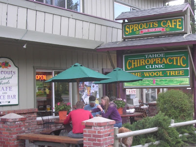
 A highway sign at Mount Rose Pass (2,714 meters) claims that it is “the highest year-round Sierra pass,” an assertion that belittles Tioga Pass’s 3,031-meter contribution, but that is true because the keyword is year-round: Tioga Pass is closed in winter.
Buttressed by the Carson Range, the Tahoe Meadows are a rare level piece of protected real estate. Ophir Creek braids its way to Incline Lake, a temporary diversion on the way to Lake Tahoe. I have attempted twice to climb Mt. Rose but turned back because of weather or time.
The trailhead accesses the amazing Tahoe Rim Trail that circles the lake in 266 glorious kilometers. I have gotten on the TRT at five entry points – clockwise: Tahoe Meadows, Spooner Summit, Heavenly Valley/Kingsbury South, Barker Pass and Brockway Summit. All have detailed informational signs and brochures of the local trail segment. Its grade rises gradually, a surprise given the elevation. Nevertheless, it seesaws between 3,151 meters (above Tahoe Meadows) and 1,902 meters at Tahoe City, the only point where it comes down to lake level and in a town. The trail doubles as the PCT on the West Shore for some 80 kilometers.

 Beyond the pass and the underrated Mount Rose ski area, the highway descends sharply towards Reno, an unremarkable community near a spectacular setting. On my list of ideal places to live, cities and towns that combines attributes of progressive politics, cultural vitality, ethnic diversity, access to outdoor activities and affordability, Reno regularly pokes its head. Not because it is liberal, edifying, multicultural or attractive. But it remains affordable and you would be hard pressed to find more variety in outdoor amenities.
Unlike Las Vegas, its casino vibe borders on the comatose. A great place to find cheap digs, thanks to the National Hotel Reservation Bureau, a reseller and consolidator that specializes in Nevada and Southern California resort destinations. We paid $40.89 to stay at the Sands, twice what it cost me last October, but still quite a deal for August. For entertainment, we visited the National Car Rental counter at the airport to be amused by the depth of questions before Nan could be added to the contract as a second driver.
“How long have you guys been together?” was the first query. National lets married couples share the driving without charging them an extra fee. The rest of the world ponies up $5 a day.
“Where can we get married?” I offered as a rebuttal.
This trip came together at the last minute and I adjusted it to include Lake Tahoe at the last second. We dropped by the Forest Service office in Truckee to get information on the PCT from Donner Pass south to Squaw Valley. Nan prepared to go ice skating at Squaw Valley’s High Camp and I figured it would be darned nifty if I could meet her there after a magnificent hike. The traditional PCT route follows the ridgeline to Tinker Knob before dropping into Shirley Canyon to the base of Squaw Valley. I wanted to know how to hook up with High Camp without descending all the way to the valley floor.
My query degenerated into a verbal tiff after I expressed disbelief that the Forest Service does not keep information on this major trail. The employee, perhaps accustomed to visitors who take no for an answer, grew frustrated and told me in no uncertain terms she did not like my tone of voice. Another employee took pity and pointed to a rack that, in fact, did have information on the PCT, albeit partitioned.
It is on the slopes of Mt. Judah that I buried, temporarily, a certain monkey that hung at the back of Patricia’s backpack, but that she offered as a birthday present. I provided her with ample directions, including photographs, of the sacred tomb, suggesting that she retrieve it and later leave it on some other mountain top. It would have been nice to see the little fellow who’s been under a boulder for two years now.
I found a far more approachable individual at the Granite Chief who delighted me her depiction of the “Forest disService.” She shared her knowledge of the trail – and several others. This spirited woman has hiked and skied all around Tahoe and beyond. In her personal biography on the sporting goods store’s Web site, she writes “ … all of this probably tells you I'm no spring chicken... but I live the lifestyle of a spring chicken. For my 50th birthday I climbed the Grand Teton in Wyoming, at 56 I climbed Half Dome. I'm a young 60-something and my passion for skiing and the mountain lifestyle has only grown stronger. If you see me in the lift line, let's take a run together.”
It would be a pleasure to do so, Madame! I love people like this!
Truckee now charges for parking, a small change in a tiny town. We ordered from the children’s menu at an expensive greasy spoon before heading out to Squaw. As a child, I participated twice in my school’s Classe de Neige program. For one month, me and my classmates lived in the Alps where we would study our regular curriculum in the morning and ski in the afternoon.
The inspiring scenery did not awe me; it frightened me. Valloire, a small village beneath the imposing Galibier Pass, manages to pack 34 lifts on a 1,170–meter vertical drop. It might have had fewer lifts in the 1970s, but its top elevation still meant a long ride down for a beginner skier with no muscles. The chairlifts leaped over impossible chasms at terrifying heights in the eyes of an 11-year-old Parisian boy. Worse, with lace-up leather boots and no-release bindings, the accident rate decimated my class. When we boarded the train back to Paris, a quarter of us wore a cast.
Not the most enticing proposition.
From age 12 to 24, I did not return to the mountains. Not to ski, at least. Until a casual winter trip to Tahoe from my San Francisco home brought me face to face with the Olympic rings at the entrance to Squaw Valley and put me in the mood to try the sport again. Elisabeth and I were not dressed for a winter outing, lacking hat, gloves and a proper jacket. We got outfitted with boots and skis, and set out for an afternoon of many falls.
But I loved it and kept great memories of this day that changed everything.
Squaw Valley’s layout bears some similarities with European resorts. It has few marked runs, leaving its bowls open for exploration. No skiing today, though. It is quite warm and the snow is long gone. (This photo dates from an earlier visit.)
 I set out on the Shirley Creek Trail, which quickly became nonexistent. I relied on cairns and splotches of blue paint, keeping the creek, swollen with muddy runoff from the previous day’s storm, to my right as I climbed. In the distance and high above, I spotted the occasional gondola coming and going. Every so often, I crossed large swaths of angled and exposed granite.


 At Shirley Lake, a sign greeted me with the novel revelation that the trail was closed due to construction. This is the same trail I was to have hiked in the opposite direction had I started at Donner Pass. It is the sort of valuable information my trip to the Forest Service office meant to dig out. It is the sort of information that ought to be disclosed, perhaps, at the trailhead, not five kilometers into a hike.


 Nan had just called – ah, the wonders of cell phones - and after contacting Squaw Valley employees, I learned of a trail to High Camp where I joined Nan who was taking in a few rays spread out on a pool chaise lounge. The skating rink was closed and she substituted frozen water for the melted variety.
 Invigorated by the hike up, I elected to walk, this time on ski area paths, and not ride the gondola down. We agreed on a time and I surprised Nan when I arrived as promised. I recalled winter visits and trips down KT 22, Squaw’s iconic peak, renown for its steeps. I chuckled when I passed a sign warning against tucking. Sounds like an invitation to me!

 We ate our lunch on the banks of the Truckee River. Not a fan of cold water, I stepped in and found it quite pleasant. Rafters and kayakers made their way north from Tahoe City and I acted as traffic cop. It was quite warm– I’d hazard low 30°’s – and the water felt awesome.

 We concluded the afternoon with a short hike on the TRT out of Brockway Summit. In the vein of the television commercial that shows an excited family at a mountain resort, eager to sample the ski runs after redeeming frequent flyer miles for the trip, Nan adopted the required stance. Like in the commercial, the only snag is that it is summer…

 The point that sticks out in the middle of the lake is Crystal Bay and marks the California-Nevada state line, which runs down from Mount Baldy to the left.
 It was time to bid farewell to the lake. We hooked onto I-80 for the short climb to Donner Pass before the inexorable descent into the Central Valley. I love that ride. Somehow, the exit names echo with the flavor of many trips. There is nothing to see at Kingvale, Cisco Grove, Yuba Gap, Laings, Emigrant Gap, Blue Canyon, Baxter. But with memories of Van Halen’s “Jump” blaring, the fusion of synthesizer pop and metal had me jumping in my seat back in the days as the highway undulated amidst forests of pine trees. Despite what she qualified as my remarkable control of high speeds, Nan prefered to look deeply within and not at the unfolding scenery.
Beyond Auburn, the road straightens as it plows through the suburbs of Sacramento, the state’s capital. A CalTrans sign warning that the three left lanes were closed got us worried when we counted but three lanes on the road. Is this a less direct way of saying closed? Up ahead in the Bay Area, motorists were preparing themselves to brave the Bay Bridge’s closure over Labor day weekend.
Sacramento pleases where other Central Valley towns disappoint. Save for much smaller Davis and Chico, it is the only sizeable city in this stretched out valley of 600 kilometers that is worth a detour. Downtown is quite lively and appeared filled with smart eateries. We stumbled upon Crepeville, an air conditioned (39° outside at freaking 9 p.m.!) bright spot with decent food, where I sat next to a guy with a DEA shirt. Drink Every Afternoon.
Our final overnight provided Nan with one last pass at wrapping her dainty body in the equally delicate but colorful Motel 6 bed spread. Book a night to see for yourself. We ran into a heavy set black man, outfitted with ritualistic bling and sporting a gold tooth. We struck a conversation with the friendly trucker from a nearby town. I am not sure I understood why he was staying in a motel…
The notion of framing a picture in such a way that it does not amputate limbs represents a challenge to many. A shot often needs to be recomposed after extremities go missing. We sat for breakfast under the porch of Parker-Lusseau, a delectable French bakery with authentic goodies in Monterey. The diminutive building once housed John C. Frémont, whose expeditions with Kit Carson mapped much of the American West. He is acknowledged as one of the first Europeans to see Lake Tahoe. His capture of the Presidio of Santa Barbara in late 1846 ended the Mexican American War. It might be during this time that he lived in Monterey, the capital of Alta California for 75 years until it moved to San Jose in 1849 after the Constitution was signed. He was one of California’s first pair of senators before becoming Arizona’s Territorial governor, and the first candidate to run for presidency of the United States on a platform opposing slavery.
 But where was I?
We walked through a large stand at Pfeiffer Big Sur on the way to a waterfall. The park store also stocks It’s It ice creams, the last reliable outpost for this Northern California treat. Not concerned about putting desert before the meal, I indulge before heading out to Nepenthe’s fabulous terrace perched 250 meters above the Pacific. We judged the deconstructed Caprese a flavorful success, augmented by the addition of a spoonful of pesto. (Ihave replicated it several times at home with heirloom tomatoes since.)
 The path to my secret overlook is short but unmarked. We squeezed past a fall tree to reach a small private opening on a rocky cliff 50 meters straight above the churning ocean. It sits on the same finger of land from where Julia Pfeiffer Burns’s trademark attraction and Big Sur icon McWay Falls cascades to the beach.
We drove lazily around the windy coast. A crowd of sightseers ambled hurriedly, snapping photographs of a half dozen supremely docile condors. The unprepossessing black birds stood on rocks and paid little attention to the procession of paparazzi angling for the best shot. Large numbered tags did not help their ungainly composure. It is the first time I see condors in the wild, although I hesitate to use that term given their lethargic disposition.
 A restaurant worker at Ragged Point related how the year’s meager rainfall has become an impediment to good hygiene. The previous day storm had dropped a scant 65 milliliters, the only precipitation, he claimed, for the entire year. A water shortage imposes a two-minute limit on showers, hardly enough, I concur, for proper scrubbing. He pointed to this restriction as the reason behind the closure of the regular washrooms.
Nan inquired about the restaurant’s facilities. They were open, but for customers only. A cup of coffee (still brewed in spite of the alleged water shortage) would not suffice to avoid the odiferous portable toilets.
“Go check out the dead bodies” I instructed.
Asleep or somnolent, the elephant seals at the Piedras Blancas Rookery resemble corpses abandoned on a beach. When they mate, they stink.
Before heading south on the 101, we thanked our calendar good fortune and stopped by the San Luis Obispo Farmers Market. The Thursday event stretches along six blocks of downtown’s Higuera Street. It is an extravagant collection of vendors hawking fruit and vegetables while local restaurants barbecue meats on large outdoor grills and bands entertain the diners. They were introduced as Irish dancers, but I had trouble picturing the Emerald Isle. It also attracts a large number of nonfood vendors that in my opinion detract from the initial vision.

 Back home in Santa Barbara, Elisabeth had made reservations at Zen Yai (no Web site, sadly) where we reminisced and savored great Thai food.
 Before I dropped her off at LAX Nan remarked that she had never gone on a trip like that, and might never again. I am grateful to have met again many old friends this past year. I cannot escape the melancholy of an unambiguous finality, however undefined. I don’t know what is ahead.
 The road to Lake Tahoe climbed over Deadman and Conway summits, Monitor, Carson and Luther passes, none much higher than 2,600 meters. We didn’t have to go over Carson, but that is where the trailhead for the short hike to Frog Lake on the Pacific Crest Trail begins. Nan could not contain her elation and went into a convulsion as we crossed into the Mokelumne Wilderness – and not just because she could not pronounce it.
 The PCT links Mexico and Canada, gasp, on an epic 4,250-km affair filled with superlative scenery. I have hiked many segments in the three states that it traverses, but never anything more involved that a daytrip.
 Near Lake Tahoe’s Emerald bay, we got stuck in traffic while a tow trucked pried free a car towing a long trailer that had gotten stuck at a steep hairpin turn. Get these monsters off the road!The Angora wildfire raged nearby in late June, consuming 254 residences and 75 outbuildings on 1,255 hectares. Two days after it was contained, Elisabeth and I happened upon Zaca Lake in the Santa Barbara backcountry where a pipe dragged through dry grass sparked a small fire. It would take almost two months to snuff it out after it had burned through 97,208 hectares – almost 10 times the size of Paris. It burned a single outbuilding.
 We dined on wholesome and tasty vegetarian fare (I had an imaginative rice bowl with a guacamole spread) at Sprouts, a South Lake Tahoe eatery recommended by Eric, the man with definite eating habits. I also stooped by Alpen Sierra, the coffee house where we met in June 2005.
 Am I getting sentimental?
 A highway sign at Mount Rose Pass (2,714 meters) claims that it is “the highest year-round Sierra pass,” an assertion that belittles Tioga Pass’s 3,031-meter contribution, but that is true because the keyword is year-round: Tioga Pass is closed in winter.
Buttressed by the Carson Range, the Tahoe Meadows are a rare level piece of protected real estate. Ophir Creek braids its way to Incline Lake, a temporary diversion on the way to Lake Tahoe. I have attempted twice to climb Mt. Rose but turned back because of weather or time.
The trailhead accesses the amazing Tahoe Rim Trail that circles the lake in 266 glorious kilometers. I have gotten on the TRT at five entry points – clockwise: Tahoe Meadows, Spooner Summit, Heavenly Valley/Kingsbury South, Barker Pass and Brockway Summit. All have detailed informational signs and brochures of the local trail segment. Its grade rises gradually, a surprise given the elevation. Nevertheless, it seesaws between 3,151 meters (above Tahoe Meadows) and 1,902 meters at Tahoe City, the only point where it comes down to lake level and in a town. The trail doubles as the PCT on the West Shore for some 80 kilometers.
Beyond the pass and the underrated Mount Rose ski area, the highway descends sharply towards Reno, an unremarkable community near a spectacular setting. On my list of ideal places to live, cities and towns that combines attributes of progressive politics, cultural vitality, ethnic diversity, access to outdoor activities and affordability, Reno regularly pokes its head. Not because it is liberal, edifying, multicultural or attractive. But it remains affordable and you would be hard pressed to find more variety in outdoor amenities.Unlike Las Vegas, its casino vibe borders on the comatose. A great place to find cheap digs, thanks to the National Hotel Reservation Bureau, a reseller and consolidator that specializes in Nevada and Southern California resort destinations. We paid $40.89 to stay at the Sands, twice what it cost me last October, but still quite a deal for August. For entertainment, we visited the National Car Rental counter at the airport to be amused by the depth of questions before Nan could be added to the contract as a second driver.
“How long have you guys been together?” was the first query. National lets married couples share the driving without charging them an extra fee. The rest of the world ponies up $5 a day.
“Where can we get married?” I offered as a rebuttal.
This trip came together at the last minute and I adjusted it to include Lake Tahoe at the last second. We dropped by the Forest Service office in Truckee to get information on the PCT from Donner Pass south to Squaw Valley. Nan prepared to go ice skating at Squaw Valley’s High Camp and I figured it would be darned nifty if I could meet her there after a magnificent hike. The traditional PCT route follows the ridgeline to Tinker Knob before dropping into Shirley Canyon to the base of Squaw Valley. I wanted to know how to hook up with High Camp without descending all the way to the valley floor.
My query degenerated into a verbal tiff after I expressed disbelief that the Forest Service does not keep information on this major trail. The employee, perhaps accustomed to visitors who take no for an answer, grew frustrated and told me in no uncertain terms she did not like my tone of voice. Another employee took pity and pointed to a rack that, in fact, did have information on the PCT, albeit partitioned.
It is on the slopes of Mt. Judah that I buried, temporarily, a certain monkey that hung at the back of Patricia’s backpack, but that she offered as a birthday present. I provided her with ample directions, including photographs, of the sacred tomb, suggesting that she retrieve it and later leave it on some other mountain top. It would have been nice to see the little fellow who’s been under a boulder for two years now.
I found a far more approachable individual at the Granite Chief who delighted me her depiction of the “Forest disService.” She shared her knowledge of the trail – and several others. This spirited woman has hiked and skied all around Tahoe and beyond. In her personal biography on the sporting goods store’s Web site, she writes “ … all of this probably tells you I'm no spring chicken... but I live the lifestyle of a spring chicken. For my 50th birthday I climbed the Grand Teton in Wyoming, at 56 I climbed Half Dome. I'm a young 60-something and my passion for skiing and the mountain lifestyle has only grown stronger. If you see me in the lift line, let's take a run together.”
It would be a pleasure to do so, Madame! I love people like this!
Truckee now charges for parking, a small change in a tiny town. We ordered from the children’s menu at an expensive greasy spoon before heading out to Squaw. As a child, I participated twice in my school’s Classe de Neige program. For one month, me and my classmates lived in the Alps where we would study our regular curriculum in the morning and ski in the afternoon.
The inspiring scenery did not awe me; it frightened me. Valloire, a small village beneath the imposing Galibier Pass, manages to pack 34 lifts on a 1,170–meter vertical drop. It might have had fewer lifts in the 1970s, but its top elevation still meant a long ride down for a beginner skier with no muscles. The chairlifts leaped over impossible chasms at terrifying heights in the eyes of an 11-year-old Parisian boy. Worse, with lace-up leather boots and no-release bindings, the accident rate decimated my class. When we boarded the train back to Paris, a quarter of us wore a cast.
Not the most enticing proposition.
From age 12 to 24, I did not return to the mountains. Not to ski, at least. Until a casual winter trip to Tahoe from my San Francisco home brought me face to face with the Olympic rings at the entrance to Squaw Valley and put me in the mood to try the sport again. Elisabeth and I were not dressed for a winter outing, lacking hat, gloves and a proper jacket. We got outfitted with boots and skis, and set out for an afternoon of many falls.
But I loved it and kept great memories of this day that changed everything.
Squaw Valley’s layout bears some similarities with European resorts. It has few marked runs, leaving its bowls open for exploration. No skiing today, though. It is quite warm and the snow is long gone. (This photo dates from an earlier visit.)
 I set out on the Shirley Creek Trail, which quickly became nonexistent. I relied on cairns and splotches of blue paint, keeping the creek, swollen with muddy runoff from the previous day’s storm, to my right as I climbed. In the distance and high above, I spotted the occasional gondola coming and going. Every so often, I crossed large swaths of angled and exposed granite.

 At Shirley Lake, a sign greeted me with the novel revelation that the trail was closed due to construction. This is the same trail I was to have hiked in the opposite direction had I started at Donner Pass. It is the sort of valuable information my trip to the Forest Service office meant to dig out. It is the sort of information that ought to be disclosed, perhaps, at the trailhead, not five kilometers into a hike.

 Nan had just called – ah, the wonders of cell phones - and after contacting Squaw Valley employees, I learned of a trail to High Camp where I joined Nan who was taking in a few rays spread out on a pool chaise lounge. The skating rink was closed and she substituted frozen water for the melted variety.
 Invigorated by the hike up, I elected to walk, this time on ski area paths, and not ride the gondola down. We agreed on a time and I surprised Nan when I arrived as promised. I recalled winter visits and trips down KT 22, Squaw’s iconic peak, renown for its steeps. I chuckled when I passed a sign warning against tucking. Sounds like an invitation to me!

 We ate our lunch on the banks of the Truckee River. Not a fan of cold water, I stepped in and found it quite pleasant. Rafters and kayakers made their way north from Tahoe City and I acted as traffic cop. It was quite warm– I’d hazard low 30°’s – and the water felt awesome.
 We concluded the afternoon with a short hike on the TRT out of Brockway Summit. In the vein of the television commercial that shows an excited family at a mountain resort, eager to sample the ski runs after redeeming frequent flyer miles for the trip, Nan adopted the required stance. Like in the commercial, the only snag is that it is summer…
 The point that sticks out in the middle of the lake is Crystal Bay and marks the California-Nevada state line, which runs down from Mount Baldy to the left.
 It was time to bid farewell to the lake. We hooked onto I-80 for the short climb to Donner Pass before the inexorable descent into the Central Valley. I love that ride. Somehow, the exit names echo with the flavor of many trips. There is nothing to see at Kingvale, Cisco Grove, Yuba Gap, Laings, Emigrant Gap, Blue Canyon, Baxter. But with memories of Van Halen’s “Jump” blaring, the fusion of synthesizer pop and metal had me jumping in my seat back in the days as the highway undulated amidst forests of pine trees. Despite what she qualified as my remarkable control of high speeds, Nan prefered to look deeply within and not at the unfolding scenery.
Beyond Auburn, the road straightens as it plows through the suburbs of Sacramento, the state’s capital. A CalTrans sign warning that the three left lanes were closed got us worried when we counted but three lanes on the road. Is this a less direct way of saying closed? Up ahead in the Bay Area, motorists were preparing themselves to brave the Bay Bridge’s closure over Labor day weekend.
Sacramento pleases where other Central Valley towns disappoint. Save for much smaller Davis and Chico, it is the only sizeable city in this stretched out valley of 600 kilometers that is worth a detour. Downtown is quite lively and appeared filled with smart eateries. We stumbled upon Crepeville, an air conditioned (39° outside at freaking 9 p.m.!) bright spot with decent food, where I sat next to a guy with a DEA shirt. Drink Every Afternoon.
Our final overnight provided Nan with one last pass at wrapping her dainty body in the equally delicate but colorful Motel 6 bed spread. Book a night to see for yourself. We ran into a heavy set black man, outfitted with ritualistic bling and sporting a gold tooth. We struck a conversation with the friendly trucker from a nearby town. I am not sure I understood why he was staying in a motel…
The notion of framing a picture in such a way that it does not amputate limbs represents a challenge to many. A shot often needs to be recomposed after extremities go missing. We sat for breakfast under the porch of Parker-Lusseau, a delectable French bakery with authentic goodies in Monterey. The diminutive building once housed John C. Frémont, whose expeditions with Kit Carson mapped much of the American West. He is acknowledged as one of the first Europeans to see Lake Tahoe. His capture of the Presidio of Santa Barbara in late 1846 ended the Mexican American War. It might be during this time that he lived in Monterey, the capital of Alta California for 75 years until it moved to San Jose in 1849 after the Constitution was signed. He was one of California’s first pair of senators before becoming Arizona’s Territorial governor, and the first candidate to run for presidency of the United States on a platform opposing slavery.
 But where was I?
Maybe it was the strong coffee, but Nan fully mutilated me and cut off my torso and head. What remains, though, is widely acknowledged as endearingly significant: my legs! Like fans the world over, I marvel at the fine and defined lines …. The back light on the “official” portrait silhouettes me against a sky filled with puffy tropical clouds, remnants of Pacific hurricanes that tagged us all week.
I took Nan on a poor man’s tour of the peninsula coastline, eschewing the 17-Mile Drive. The pay-to-view road is the only access point to tony Pebble Beach and its collection of estates. Toll booths act as de facto screeners of the character and bona fides of incoming visitors. The cypress forest and sand dunes function as a moat around privilege. Imagine the possibilities of controlling access to an entire town!
But on the craggy shore of Monterey and Pacific Grove most houses, no doubt quite pricey, looked like homes and not mansions. Nan loved Asilomar, the understated hotel in the midst of cypress and dunes. With reverence, I let my fingers caress the very table where I claimed ping pong glory on the very first day of the year.
A thin morning veil of fog still shrouded he rocky headlands of Garrapata, a clear indication that we had long left the crisp mountain air behind. The water froths when waves die off violently against promontories. When it settles, it is impossibly crystal clear. Still, it is easy to confuse bobbing kelp for heads of see otters. We heard but did not see sea lions. Also hidden in Soberanes Canyon is one of the last groves of redwoods.
 A little bit down the coast, a jelly fish of fog lingered above Point Sur and oddly obscured it.
 The cousins to sequoias reach the southern end of their range in the Big Sur region. It is in these parts that rains become less plentiful. Progressively, lush forests will cede to coastal sage and chaparral. Below Point Conception, only isolated stands grace the coastline.
The back light on the “official” portrait silhouettes me against a sky filled with puffy tropical clouds, remnants of Pacific hurricanes that tagged us all week. 
I took Nan on a poor man’s tour of the peninsula coastline, eschewing the 17-Mile Drive. The pay-to-view road is the only access point to tony Pebble Beach and its collection of estates. Toll booths act as de facto screeners of the character and bona fides of incoming visitors. The cypress forest and sand dunes function as a moat around privilege. Imagine the possibilities of controlling access to an entire town!
But on the craggy shore of Monterey and Pacific Grove most houses, no doubt quite pricey, looked like homes and not mansions. Nan loved Asilomar, the understated hotel in the midst of cypress and dunes. With reverence, I let my fingers caress the very table where I claimed ping pong glory on the very first day of the year.
A thin morning veil of fog still shrouded he rocky headlands of Garrapata, a clear indication that we had long left the crisp mountain air behind. The water froths when waves die off violently against promontories. When it settles, it is impossibly crystal clear. Still, it is easy to confuse bobbing kelp for heads of see otters. We heard but did not see sea lions. Also hidden in Soberanes Canyon is one of the last groves of redwoods.
 A little bit down the coast, a jelly fish of fog lingered above Point Sur and oddly obscured it.
 The cousins to sequoias reach the southern end of their range in the Big Sur region. It is in these parts that rains become less plentiful. Progressively, lush forests will cede to coastal sage and chaparral. Below Point Conception, only isolated stands grace the coastline.
 We walked through a large stand at Pfeiffer Big Sur on the way to a waterfall. The park store also stocks It’s It ice creams, the last reliable outpost for this Northern California treat. Not concerned about putting desert before the meal, I indulge before heading out to Nepenthe’s fabulous terrace perched 250 meters above the Pacific. We judged the deconstructed Caprese a flavorful success, augmented by the addition of a spoonful of pesto. (Ihave replicated it several times at home with heirloom tomatoes since.)
 The path to my secret overlook is short but unmarked. We squeezed past a fall tree to reach a small private opening on a rocky cliff 50 meters straight above the churning ocean. It sits on the same finger of land from where Julia Pfeiffer Burns’s trademark attraction and Big Sur icon McWay Falls cascades to the beach.
We drove lazily around the windy coast. A crowd of sightseers ambled hurriedly, snapping photographs of a half dozen supremely docile condors. The unprepossessing black birds stood on rocks and paid little attention to the procession of paparazzi angling for the best shot. Large numbered tags did not help their ungainly composure. It is the first time I see condors in the wild, although I hesitate to use that term given their lethargic disposition.
 A restaurant worker at Ragged Point related how the year’s meager rainfall has become an impediment to good hygiene. The previous day storm had dropped a scant 65 milliliters, the only precipitation, he claimed, for the entire year. A water shortage imposes a two-minute limit on showers, hardly enough, I concur, for proper scrubbing. He pointed to this restriction as the reason behind the closure of the regular washrooms.
Nan inquired about the restaurant’s facilities. They were open, but for customers only. A cup of coffee (still brewed in spite of the alleged water shortage) would not suffice to avoid the odiferous portable toilets.
“Go check out the dead bodies” I instructed.
Asleep or somnolent, the elephant seals at the Piedras Blancas Rookery resemble corpses abandoned on a beach. When they mate, they stink.
Before heading south on the 101, we thanked our calendar good fortune and stopped by the San Luis Obispo Farmers Market. The Thursday event stretches along six blocks of downtown’s Higuera Street. It is an extravagant collection of vendors hawking fruit and vegetables while local restaurants barbecue meats on large outdoor grills and bands entertain the diners. They were introduced as Irish dancers, but I had trouble picturing the Emerald Isle. It also attracts a large number of nonfood vendors that in my opinion detract from the initial vision.

 Back home in Santa Barbara, Elisabeth had made reservations at Zen Yai (no Web site, sadly) where we reminisced and savored great Thai food.
 Before I dropped her off at LAX Nan remarked that she had never gone on a trip like that, and might never again. I am grateful to have met again many old friends this past year. I cannot escape the melancholy of an unambiguous finality, however undefined. I don’t know what is ahead.
No comments:
Post a Comment