
Once of the small pleasure of traveling, more accurately of returning from travels, is to be picked up by a friend of family member at the airport. After landing at Orange County, my phone beeped one message: Eric could not pick me up as planned.
While my luggage was making its way to the carousel, I approached a man wearing a Super Shuttle jacket to inquire whether they could drop me off at the Hyatt Regency in Huntington Beach where I would be staying with Eric while he attended a conference. Twice he asked me which company I wanted to use. His question startled me given the logo on his jacket, but I deduced that he acted as an impartial (!) representative for several shuttle companies.
“You’re gonna need an exclusive,” he snapped when I returned from the terminal with my two bags and skis.
“A what??”
The $24 fare he quoted me included transportation for me and my bags, not the skis. Because he said the skis would not fit in the van without inconveniencing other passengers, I needed to hire an entire van.
“What the hell!!!!!!!!!”
He never did divulge what the charge is for an “exclusive,” and immediately offered me a deal. $79. Just for me. Seventy-nine bucks to go 15 km!
I realize that Orange County is not much of a ski destination, but people do return from ski trips and have gear with them. This has never been an issue in any of the cities I have visited. Offended, I declined the offer, smelling more a scam than a deal. An urgent phone call to Eric landed in his voice mail, and after 10 minutes I approached the driver of another company to plead my case.
“I tell you what. For you I make special rate. $49?”
Welcome to California’s Republican paradise of eternal sunshine and uncompromising business principles. This might fall, actually, under variable pricing, whereas the price of a product or service is constantly adjusted to maximize profits. Think airline seat inventory strategy brought down to the common marketplace. If it is very warm today, that is reason enough to increase the cost of water, isn’t it? In the abstract, since the cost of the actual product is more and more irrelevant, my liter of water can be 50 cents, a couple dollars, a steep-but-oh-so-worth-it $5. Go fight it out.
So I played the Third World haggling game – with Eric’s money. Not the greatest way to kick off part II of a vacation, I’ll grant you that. More than ever, I was grateful for Rebecca who gave me a ride to the Santa Barbara airport when I flew to Albuquerque.
Eric e-mailed me six weeks ago with the good news: coming to conference in Huntington Beach … STOP … thinking about taking a few days off afterwards … STOP … want to go on a trip? … STOP … where do you think we could go? … STOP … await reply … STOP
With the memories of our Northern Arizona fabulous adventure still fresh on my mind, I started floating ideas that would take us to San Diego, Anza Borrego, Palm Springs and back to Santa Barbara. With growing excitement, days and destinations were added until what you are about to read – God help you – materialized.
Eric arrived a day early while I was still in New Mexico and visited notable sights in Los Angeles. He came to Southern California for an SAP conference, a subject of enormous interest to me, but on which I will not dwell. At an outdoor buffet for conference attendees our first night together, I listened politely as he conversed with a couple about the wonders and merits of this software. (SAP is a software, this much I am certain of.)
“As sexy as this discussion is, I have to ask you to excuse myself” I announced at the table. Eric joined me a little while later in our elegant room and we talked into the night. In spite of my arrival contretemps, it was great to see him again.

Surf City
Nothing.
Nothing is what I would do on my first full day back in California. Eric attended to his duties. I lingered and swam in the pool and lingered some more. Mid afternoon, the chilly fog finally gone, I walked on the path alongside the beach and its fire rings to Huntington Beach’s happenin’ (albeit small) downtown. Although they called Hawthorne, an inland city in the next county over, home, the Beach Boys might as well have walked the sands of Surf City. The two blocks of Main Street exude a surfing vibe and it is quite pleasant to hang around. Next to the pier is a restaurant called Chimayó (grammatically correct with the accent on the “o”) that brought me back to my home for the last five days in New Mexico, emotionally if not financially.
We drove down Highway 1, the mythical Pacific Coast Highway, which, as it plows through suburban sprawl, lacks its vaunted charm until we arrived upon Laguna Beach. Unlike northern Orange County coastal communities, it is set against a backdrop of rolling hills that adds character. The dissimilarity extends beyond the physical. Politically liberal, Laguna Beach fights against the grain in a reliably conservative county. (California’s progressive reputation is the product of a ribbon of coastal radicalism that thins to the point of extinction in the south. Populous for now, this region is losing ground to expanding and vastly more conservative inland regions.)
Our destination was farther south, just about at the San Diego County line. Since we missed the Wedge in Newport Beach, I felt it was necessary, vital, to bring Eric to an illustrious surf spot. As with most cherished spots, it takes a bit of investigation and deduction to get to the Trestles.
Eric’s GPS unit did not return a location for this famed San Clemente break. Everybody knows it, but it’s not on any map and there are no handy signs pointing to it. Observant, we followed wet-suited surfers, some on foot, others riding bikes rigged with an ingenious rack for the board.
The beach appears after walking a good kilometer on a trail through coastal vegetation. That separation from civilization imparts a bit of wilderness feel, a remarkable concept in a region with a very developed coastline. The operators of Orange County’s network of toll roads want to extend one such road and have it connect with the I-5 freeway. Plans call for the highway to go through an established state park campground. The interchange would be where the trail to the Trestles passes.
 Eric dipped his hand in the Pacific waters and promptly decided that shooting photographs was a (much) warmer pursuit. Even at the Mexican border and at the height of summer, the ocean barely registers past 20°. The air temperature also does not leap much higher. For all of our pride in having a Mediterranean climate, a persistent marine layer clogs California’s immediate coast most spring and summer mornings. The gray muck hovers until noon, at the earliest, more likely until late afternoon, generously handing us a couple of hours of sunshine before sunset. Best times to visit the coast are the fall months, or even during our ephemeral rainy season. I will advance that warm days are more common in February than in June.
An hour before sunset and the angled light suffused the moist marine air. Eric shot a little under half the photographs you see here. His picture of the train trestles (hence the name of the beach) possesses an intangible impressionistic quality that I like. (The California Coastal Record has aerial photographs of the entire coastline, save for the restricted area of Vandenberg Air Force Base. Archival images permit evocative comparisons. This is a view of the Trestles – check out this amazing site!) Follow the train tracks north a bit, you would will soon arrive at the San Clemente cove and pier. Set in a small bowl against the hillside, it gives off the allure of a small village. (The city center shockingly lacks chain stores, the primary ingredient in most urban recipes.) The rugged topography and the absence of direct access from the freeway above town ensure a benign isolation. Amtrak trains stop at the pier twice daily on their Santa Barbara to San Diego runs. A stay at the San Clemente Cove Hotel, adjacent to the beach, pier and train stop, would be a nifty and idealized getaway, but I have never been able to secure the least expensive rooms. We dropped by and a friendly receptionist gave us a tour and a few tips on how to book a room.
I shall return!
 When I hear about GPS units, I associate them exclusively with the task of finding a destination. Not an undistinguished feature, but I can read maps and find my way around on my own. Eric brought one along and its versatility amazed me. Driving around Irvine at night, it returned several locations after I punched in my bank’s name. The results came with distance and direction. Its memory handles everything a traveler might need, all in real space and time: retailers and shopping centers, schools and universities, civic and office buildings, automotive services and gas stations, parks and campgrounds, museums and landmarks, hotels and restaurants. It lets you search by name or category, and constantly adjusts the results as the vehicle moves. When we selected a destination, the GPS issued both mapped screen instruction and voice commands. Within seconds after missing a turn, it would announce that it was “recalculating” before coming up with a new set of directions.
Quite amazing. It is how I ended up slurping phó in a pretty good Vietnamese restaurant. I picked up a bike at the Hyatt’s Toes on the Nose shop (I love that name) and rode it in the chilly fog to the Bolsa Chica wetlands. Once common, many of these rich coastal habitats where aquatic and terrestrial ecosystems intersect and interface have been drained and filled. You don’t expect we are going to let prime real estate go without maximizing profit, do you? Even if the preserve is twice as far as the shop attendant claimed, even if crossing the busy PCH from the beach to the wetlands requires a life-affirming dash against the rushing traffic, even if Bolsa Chica is far from a pristine natural environment, it was a nice place to visit.
 In the middle of rush hour traffic, in an area reputed for its epic congestion, we sailed to LAX where we exchanged our sedan for a four-wheel drive in anticipation of a trip that will take us off the beaten path, deep into isolated landscapes.
First we had to leave behind an overwrought state of mind. We dipped into the Mojave Desert’s Antelope Valley – a wretched place notwithstanding its bucolic aspirations – under cover of darkness and did not look back.
From dirt to shining chert
The hike to Mount Whitney above Lone Pine is what started this blog. On my way back from Lake Tahoe last fall, I winked at my mountain. This time, I wanted to drive to the trailhead, a short 20-km trip that trades desert for forest. The road to Whitney Portal was technically closed for the season, but a guard at the road block let us by with a benevolent “We’ve never had this conversation.”
Opening a road after a winter closure hinges on far more than the mere disappearance of snow alone. Don’t ask. The views of the Owens Valley narrowly framed by the Sierra Nevada, on which we drove, and of the Inyo Mountains grew more expansive by the second. This satellite map shows these two impressive ranges. On the valley floor, it also points painfully to dry Owens Lake. Steamboats plied this lake, once the largest body of water wholly within California. That was before the runoff in all the Owens River feeder creeks, all the way to Mono Lake, 200 kms north, was diverted into the aqueduct to supply the water needs of Los Angeles.
We could not sweet talk our way into the Alabama Hills. Public lands as they are, I suppose the Bureau of Land Management figured no one would miss them on this April weekday. John Wayne, Errol Flynn, Gene Autry, Roy Rogers, Cary Grant, Humphrey Bogart and other actors have played in this fantastic land of boulders. Today, a film crew had the run of the place.
In preparation for this trip, I phoned a ranger to inquire about road conditions to the Racetrack in the Death Valley backcountry. She inquired about my transportation (four-wheel drive) and whether it was my own car (no). In one quick breath, she assured me I would get a flat tire, two, in fact, because of all the chert, and that towing is very expensive.
“Because of what?” I asked.
“Chert,” she retorted, as if the type of glassy rock is widely known. She was sufficiently adamant that I would get flat tires that I questioned whether the park service sprinkles the sharp stone on the dirt roads. And possibly colludes with tow service operators.
She didn’t get the joke. My suggestion for an alternate approach was described as “gnarly.” All in all, I felt jinxed. And even though I ought to know better, I resolved to heed her admonitions because it would also shave many kilometers off our day and permit a more leisure journey through the rest of this immense park. More often than not, park officials leave me with the impression they really would rather people not do too much beyond the well-trodden paths.
Instead, we stopped for a drink at the inviting Panamint Springs Resort. A bit of a misnomer, the property proposes a few simple rooms, R.V. and tent spaces, and an airy veranda where we settled. It is the least expensive lodging among only four options in the park.

 Death Valley comprises three other valleys, in addition to the namesake. Typical of the basin and rage topography, they trend north-south and are separated by tall mountain ranges. Going from one to the next implies climbing surprisingly steep passes.
Two years ago, the dry lake bed in the middle of the picture had water in it. The rainy season had been abundant and marvelous. Unexpected fields of wildflowers greeted me during a visit in March. This year’s total rainfall adds up to 1¼ centimeter. Normal amounts rise to 5 centimeters, still an abysmally low figure. Add a prodigious evaporation rate (375 cm at the lowest and warmest elevations) and it is a miracle life survives.


 Because of the scant precipitation, this would have been an ideal time to hike up to Telescope Peak, the highest point in the Panamint Range. Most years at this time, its 3,368-meter summit remains snowed in. Certainly, this is not the image Death Valley conjures, but both the Panamint and Amargosa ranges harbor forested slopes.
Instead of snow, we played in the sand. In early April, the midmorning heat easily passed the 30° mark. Even in these marginal conditions, mesquite trees manage to dig roots in the sand and capture enough moisture.
At 6 a.m. on Monday 23 July, at the height of summer when the mercury routinely hits 50° during the day and does not drop below 30° at night, the first wave of runners will hit the road on their way to Whitney Portal. Last year, Scott Jurek (US) covered the 217 km (and almost 4,000 meters of cumulative ascent) in 25 hours 41:18. Monica Scholz (Canada) was the first woman to cross the finish in 32 hours 07:01. But Jurek is slacking: In 2005 he established the course record with a time of 24 hours 36:08.
This is a nonstop race. Runners do not stop to eat, drink, or God forbid, sleep. Likewise, peeing is strictly on the go. It falls under the category of ultra marathon. Tips on how to approach this endurance race are at http://www.zombierunner.com/. With a name like that, you get an idea of who these people are!
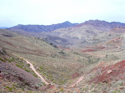
Even as I opted out of the Racetrack and Saline Valley, fearful of the ranger’s calamitous predictions, we introduced our Toyota Highlander to its first dirt in Titus Canyon. We picked up the road just over the line into Nevada, near the ghost town of Rhyolite. After a gentle climb over empty expanse of the Grapevine Mountains, it drops quickly to the abandoned settlement of Leadfield where a few buildings cling to hillsides dotted with creosote. A sign informs us that “300 hopeful people swarmed here” for a brief six months in 1926, lured to the riches promised by “wild and distorted advertising.” What else is new?
Only with heat-induced dementia can I entertain the idea of people swarming in those parts. The one-way road narrows considerably as it squeezes within the constricted grip of Titus Canyon. Eric filmed our journey around its twists and bends. The video makes me a little queasy. Before vomiting, we emerge onto a broad alluvial fan in Death Valley proper.
After she moved to Independence, the next town north of Lone Pine in the Owens Valley, Mary Austin penned her observations on desert living in “The Land of Little Rain,” a book now considered a classic of nature literature. It was only fitting that I pick up a copy at the Visitors Center before we retired to the tony Furnace Creek Inn for high tea.

 Near the oasis of the same name, this hotel is a grande dame in the tradition of luxury park lodging. Way too rich for my blood, it does serve a reasonably priced afternoon tea. The waitress must have thought we could not truly afford such rarefied establishment and decided we would share the scones and finger food. The elegant setting and the views toward the Badwater salt pans inspired but the treats were not memorable.
Unlike our short hike into Golden Canyon. The downside of this gigantic park is that it overwhelms. Death Valley itself stretches well over 100 kms and mountains on either side rise as much as 3,400 meters above the flat valley floor, at or even below sea level.
The desert exposes everything but reveals little.
All is in a raw state, unadorned with topsoil, daring us to look. The bare hills divulge their primal nakedness. We will look, but cannot rely on our usual landmarks. Without trees, shrubs, devoid of dirt, it’s just too much, too empty, too hot, too flagrant.
We venture in a canyon, drawn by an amalgam of colors on an improbable collection of fantastic, jumbled rocks. We walk on the skeleton of the earth, bruised bones and cracked joints. Passage tightens. The wind howls on the ridge tops and carries the calls of unseen birds. Golden Canyon is rough, creamy, pale, red sands that collapse with little attention to our sensibilities.

 And yet. In this oppressively parched scenery, water lurks. It is in the mountains at some time of year. It is below our feet, in underground pockets. Where it surfaces, lush oasis interrupt the tyranny of dirt. Not far from Panamint Springs, unpredictably, Darwin Falls splashes over bleached hills.
Our Death Valley escapades did not leave time to explore Pahrump, already the subject of glance in “ping pong addiction.” It is a shame because I had done some research on what a fine time can be had in this burgeoning burg. In terms of singular experience, little can top a visit to the hotbed of the local economy.
Take a side trip off the standard-issue main drag and step right in, please. The Chicken Ranch sells no poultry, fear not, but might keep a stash of feathers. Peruse the menu and reflect its originality. Why not start with a “Bubble Bath” or a “Breast Massage”? This preamble, of course, may only lead to a “Straight Lay,” unless a “Vibrator Party” is preferred. Get your just desserts with “Crème de Menthe French,” unless you feel adventurous and want to order from the à la carte (“A primary sex activity generally leading to the man's climax”) or the ranch specialties (“Complete course of fun and sex”). Pick amongst the straightforward “Bondage,” and “Drag Party,” although the “Audio Delight” and “Bungalow” specials sound inviting, if mysterious.
The Chicken Ranch, at 10511 Homestead Rd., and its neighbor Sheri’s Ranch, at 10551 Homestead Rd., ply the best of the brothel trade. Strictly a straight affair, they propose dozens of ladies of the night who, in this case, work around the clock for your pleasure.
Tell Sinful Angel (anointed sultry European lover) I sent you, although I can see why some would prefer Anita, the über Barbie bombshell, or Girlie, the insatiable seductress. Heck, why not purr along with Kittie, the cute busty redhead?
How much, you ask?
Gentlemen never ask, you know? The Chicken Ranch’s Web site stipulates that “due to the fact that the ladies are independent contractors, we cannot quote prices.” The strategy is to arrive prepared with “a general idea of what activities you are interested in” so that the ladies are “able to negotiate with you.” Chains, whips, wax (yikes) cost extra: That stuff ain’t cheap.
I don’t think a $20 will get you too far, but management hawks a few good deal. Print a $50-off coupon, which will be doubled if you present a drivers license from a western state. Couples and the military (yeah for Iraq!) qualify for $100 off. Like savvy retailers, they will match competitors coupons! You may score frequent flyer points out of the adventure.
 Seated near a window overlooking an artificial lake, we spied the periodic choreographed fountain shows. Against the backdrop of the Eiffel Tower and profuse nighttime lights, it is a beautiful spectacle, even if we could not hear the accompanying music.
 Once the epitome of cheap stuff, this city has reinvented itself as an upscale destination. I wrote a fine article (eh eh) on the subject, so I won’t repeat my observations. With upgraded amenities and service (less so of the latter), one expects prices to spike. And they have, at all levels. Shintaro does its bit in pricing a cup of regular coffee for $10. French press, yes, but no refills. Add tax and tip and savor your $12.28 cup.
A UNLV study shows that, between 2000 and 2006, the number of visitors to Las Vegas has increased 8.6 percent to 39 million. During the same period, the number of rooms has grown by 6.7 percent and the average daily rate has surged 61 percent. Sin City boasts 151,000 hotel rooms, more than any city in the world, with another 11,000 under construction and 35,000 on the drawing boards. A phenomenal 89.7 percent occupancy rate fuels this frenzy. In this city, where odds are famously stacked against the visitor, I would not bet on lower room rates any time soon. Save tons of cash by steering clear of weekend and holiday periods. Come in June, July and August for the best deals; avoid March, September and November when rates are highest.
The study indicates that more than a quarter of the tourists who answer the call of nonstop gambling, free-flowing booze and legalized prostitution hail from the Midwest and the South. The same people, no doubt, who gesticulate their moral superiority at every occasion.
Eric took a picture of a vending machine in Belgium. Look closely at choice of beverages. You have the customary soda, energy drink and mineral water (priced cheaper than either). The thirsty customer may also select from five beers and two wines. I won’t pass judgment on the prudence of refrigerating red wine, but I am elated that a Duvel, a mighty fine Belgium brew, is only €2.10. A bottle of Brugs is a steal at €1.20 – cheaper than the Coke!
This brazen vending machine is accessible to everyone. Imagine the terror if we knew that our little ones, free from our reactionary drinking laws, could pop a coin or two and score booze. It would be a tragedy. I have no issue with a 16 year old having a beer; I am seriously opposed to the same teenager being allowed access to weapons.
 On our way to our St. George, Utah, motel, we whizzed past Mesquite, the closest Nevada town to Southern Utah. On previous visits, I have noted the near totality of cars in casino lots bear Utah plates. That is coming from a state where even drinking coffee is interpreted as a religious offense.
Calm down, hypocrites, won’t you?
Men (and women) standing up like angels
Of my several trips to Zion, it is my first to the Kolob Terraces. This is why I can return time and again to a park and not feel as if I am reliving the same experience. Eternally slow, I need to come back to get it. Not many share this philosophy.
The road to the Terraces does not see much traffic. It passes gorgeous private ranches framed by solitary sandstone formations. Salmon-colored cliffs line broad meadows. It is also the access for the Subway, one of the park’s signature expedition through a canyon’s narrows.

 It is a delightful day on the Colorado Plateau. We travel the Northgate Peaks Trail, level despite its name, through ponderosa pines to a viewpoint above the left fork of North Creek. In a state bursting with awe-inspiring scenery, the naming of this creek follows the commonplace convention for street addresses. A typical Utah location may be 123 West 456 North. Poetic, no? Once you get used to it, it is easy to navigate but it sounds a little too efficient.
 We intersect the Wildcat Canyon Trail. A right turn and we could arrive, eventually, into Zion Canyon by way of the West Rim Trail. Instead, we double-back – the Kolob Terrace Road becomes a dirt road a little ways past Lava Point on its way to Cedar City – and arrive at Springdale, a busy burg smack against the park’s South Entrance. I am a bit alarmed when I notice scores of vehicles parked alongside the road. After flashing my park pass and keeping $25 in my pocket, we stumble upon a recently liberated spot in a very full parking lot. The owner of the next car over keeps the engine idling for delightful effect.
As much as I perpetually shy from designating a park or a hike – or anything, for that matter – as a favorite, Zion is home to an amazing trail. With great excitement, we board the mandatory shuttle, an excellent way to reduce traffic, obviously, but also to foster interaction between people.
The trailhead is across the road from the Grotto stop. Craning our necks, I point our destination to Eric. Angel’s Landing, an arête ridgeback, looms half a kilometer above our heads. The first time I hiked it, in winter, I queried a ranger on trail conditions.
“If there’s snow, it’ll be slippery. If it’s slippery, you’ll fall. If you fall, you die,” he said.
Does anyone need more of an invitation?
We paused to watch a young dude play on a cottonwood that arches over the Virgin River. I like when people push their own boundaries. It’s not about being foolish – it’s about being alive.


 Under a full sun, the trail hugs the steep canyon face and sometimes has, in fact, been carved into the sandstone. Through a beautifully engineered series of switchbacks we reach the shade of a hanging ravine, Refrigerator Canyon. With 21 tight and successive switchbacks, Walter’s Wiggles deliver us to Scout’s Lookout where we can gaze at the Virgin’s placid meanders past the Organ toward the Temple of Sinawava. At the viewpoint, the final approach to Angel’s Landing stares at us. It is decision time for the fear of heights crowd. It’s not so much that the trail turns more vertical. There’s the question of the pesky drop offs, on either side. To facilitate progress, the Park Service has bolted chains and cables into the rock. With each step, the distance straight down to the canyon floor increases and the width of the ridgeback shrinks. It is simply thrilling to climb in these surroundings, and I did have to goof around some and hang from the chains. Under my weight, the chain quickly lost its slack and I fell back. Surprise, surprise …


 The park’s Web site does list five people who have fallen to their death during the ascent to this magnificent perch. The most recent casualty was a 29-year-old Nevada woman in August 2006. On Internet posts, a few call for additional safety measures, in typical rash reaction. It would be a shame to sanitize this classic hike.

 Adorned with hip-waders and rubber boots, a few souls were returning from their day sloshing the frigid waters in the Narrows when we arrived to check them out. From the Temple of the Sinawava monolith at the end of the road, a trail parallels the Virgin River for about 1½ km before the canyon walls narrow and force foot traffic into the waterway. I have hiked as far as the confluence with Orderville Canyon where I could touch both walls with my arms outstretched. Absolutely gorgeous.
 On the other side of the long tunnel, the Checkerboard Mesa presents a strikingly different face. Soft, rounded hills replace the sheer cliffs. We stopped by the Buffalo Grill at Zion Mountain Resort for a pleasant dinner on the outskirts of the park. We joked and teased our waitresses, and had a regal time. The evening specials sold out, so we turned our attention to the grazing animals in the pasture and selected the buffalo steak. As it happened, the beasts outside our window serve as mascots and are not eaten. Our steaks came from Colorado. We chatted with an Israeli man who spoke French because, he said, he was raised in Egypt.

Red rocks standing up like men
It took several visits to Zion before I made it to Bryce, even though it is a little over an hour away. At elevations between 2,400 meters and 2,800 meters atop the Paunsaugunt Plateau, its striking feature is how the land collapses into a labyrinth of widely eroded and colorful spires. After breakfast in Panguitch where an beleaguered but gentle waitress called Eric “honey,” he dropped me off at a trailhead outside of Tropic and I hiked along dry Bryce Creek into the park to meet him at Sunset Point. Never mind that the park faces east …


 Eric was stoked after enjoying a most delicately balanced espresso in Tropic. The trail into Wall Street unfortunately was closed due to a landslide. This killed the loop part of our planned hike. Not totally deterred by such considerations, I might have made a go of it. Nearby, I overheard a ranger explaining why hiking into the Silent City was a bad idea. He offered that we hiked back down on the Navajo Loop and a few meters to the Wall Street closure so we could see the slide. A sign informed us, in exacting language, of the consequences of ignoring the closure. Trespassers, as they are called, risk fines totaling $725 if they dare disobey the warning and hike a slide that dates back to last year.
 Still, we enjoyed a nice loop in the amphitheater below the rim, even as we found no water under the Two Bridges, and not much at all in terms of flowers in the Queen’s Garden. We circled hoodoos and other unique rock formations, created when melting snows once again freezes during winter and cracks the limestone. This frost wedging process fractures the rock that will further be eroded when the (natural) acidity in rain water will dissolve the limestone. Because the top layer is made up of more resistant dolomite, it is not rare to notice a formation, like Thor’s Hammer, with a caprock precariously perched atop a weaker foundation. Alternatively, you can blame an angry coyote who, according to Paiute legend, turned people into rock.


 In the parking lot I spotted a very un-Utah car, decorated with a dozen bumper stickers, each more liberal sounding than the next. To wit: “Iraq is Arabic for Vietnam,” “Your ignorance is their power,” “Sorry I missed church: I’ve been busy practicing witchcraft and becoming a lesbian,” “Warning: Driving causes air pollution, global warming, roads, sprawl, loss of habitat, traffic jams, accidents, malls & is linked to resource wars,” “Was Columbus a terrorist or an illegal alien?” and a personal favorite, “I don’t mind straight people as long as they act gay in public.”
Utah exacerbates the conservative ideology that resonates in most parts of the mountain states in the Western U.S. Outside of Salt Lake City representatives, the Utah delegations to the Statehouse and to Congress are 100 percent Republican. There is no opposition. Everyone happily thinks the same.
Enter Rocky Anderson. In this cauldron of conformity, the outspoken Salt Lake City mayor enrages those more accustomed to quiet complacency. He has brought to his office a passionate devotion to causes that barely register on the national political stage. He has called for impeachment of President Bush because of the war in Iraq, which he calls illegal.
He accuses Democrats of running toward the center, away from confrontation. He will not seek a mayoral third term; I hope his name shows up somewhere in the future.''There's a dangerous culture of obedience throughout much of this country that's worse in Utah than anywhere,'' he says. I fully share his assessment, a paradoxical judgment in the land of independence.

 We took in a ranger program and headed for the southern end of the park, glancing peeks into the Pink Cliffs lowlands as the road climbed to the densely forested Rainbow and Yovimpa points. At 2,778 meters, the air was chilly and I spotted snow patches. To the south, across the Kaibab Plateau and the state line in Arizona rose solitary Navajo Mountain on the rez. Last summer’s hike to Keet Seel took place in its foothills.

Gray clouds gathered and in no time liberated a few drops that attracted a few others and became rain. We gathered outside the motel that serves as Grand Staircase ATV’s operational base in Tropic. With three other participants – a family from upstate New York – we debated the merits of going on an all-terrain-vehicle ride during a storm. Soon, the wet weather moved on and that was all we needed to sign on. The irksome issue of no winter coat surfaced again, but owner Justin lent me a camouflage jacket. With its slight wild animal scent, and a dead one at that, permeating around me I saddled the mechanic beast and listened to the instructions.
Operating an ATV is straightforward, with gear switching done with the flick of a lever. We rode out of town past pleasant Mormon farm plots, including the land homesteaded in 1875 by Tropic founder, Ebenezer Bryce of Scotland. I don’t suppose I need to tell you who the park was named after?
An anomaly, the Utah landscape is full of small functioning villages. Twice settled but never abandonned like mining towns throughout the West, most of its 18th century settlements have survived. Credit LDS dedication and commitment.


 Justin’s family traces its roots to Bryce’s generation and he shared a knowledge we could not get from research. Below a coal bench and near a mine where his father once worked, he explained the area is rich in fossils. As he did, he picked up a random rock and split it in half to reveal one. If this were Hollywood, I would question it.
 As we grew more confident handling our sputtering machines, the pace increased. Eric shot a video of me riding convincingly on my ATV but did not save it. No moment of fame for me, uh? He was taken to task for driving with a little too much abandon and spraying Bree, Justin’s wife who accompanied us on the tour, with a curtain of sand and pebbles.
We goofed around on our way to the mesa top where somber clouds had assembled once more. On a radio call into town, Justin learned it was raining hard and offered to wait for a trailer to haul us out.
No, no, no …. We like it like that. We like that rain! Our little group made its way down in the dark, lascerated by the driving rain, and elated. Not a fan of mechanized sports on public lands, I will confess to enjoying the thrill of this ride. Justin let me ride without a helmet and I loved the wild feel of wind rushing in my hair.
Food, and how not to eat it
We stepped in the dining room to hear that they had stopped serving food for the night. Barely 9 o’clock on a Saturday night, we retreated to our little cabin with dried oranges and cranberries, crackers, salad greens but no dressing.
This is my second stay in one of the small cabins rented by the Escalante Outfitters folks who also sell outdoor supplies and operate a restaurant that shuts down early. Elisabeth and I spent a sweltering August night in Escalante, attracted by the log construction and the $24.95 rate. Four years and a new owner later, the cabins now go for $44.95, still reasonable if inflationist. I made certain they had heaters. During my last visit, it was uncomfortably hot and we slept with the door wide open and the fan going full blast.
Breakfast consisted of coffee only as the sole dish on the menu did not appeal. It was a meager beginning to tackle a park the size of the Grand Staircase-Escalante, one of the nation’s newest, designated as national monument by President Clinton in 1996, not without controversy. A national monument can be fashioned out of presidential decree, whereas a national park requires Congress approval, a nod that would not have come, even if the park’s management plan includes energy and mineral extraction.
When visitors gaze westward from Bryce Canyon viewpoints, most of what they see is the Grand Staircase. The vast park stretches over too much land to comprehend. The Paunsaugunt and Aquarius plateaus, Vermillion Cliffs and Glen Canyon/Lake Powell hem a high desert landscape that remained terra incognita long after other lands had been surveyed. The BLM, first time caretaker of a National Park property, showcases its pride in five, yes five visitor centers located around the periphery of the park. Only two paved highways gain access to the north and south, with several graded dirt roads linking them.

 The “grand staircase” appelation refers to the staggering of geologic layers. In broad terms, the very top rock layer at the Grand Canyon sinks to the bottom of Zion Canyon. Zion’s top layers, in turn, act as the lowest ones in Bryce. This graduated progression is visible through the park’s western region through the White, Grey and Pink cliffs. The long mesa of the Kaiparowits Plateau marches through the middle of the park. Its paleontological sites attracts worldwide attention. Its fossils draw energy companies. Hundreds of Escalante River tributaries round out the eastern side.


 Immediately it was a narrow fit. With each slow step the canyon walls constricted. We moved forward sideways, crab-like. At a rare opening, we let a hiker pass on his way down. I can imagine the serious choke points if too many people happen on the same spot. We heard of a group who has trouble making it past a squeeze up over a vertical crevasse. The walls are a little wider than my shoulders and reach up to 6 meters. Another hiker catches up with us. He looks ready for a faster pace but there is no way for him to pass me unless he crouches between my legs. At the first tight chimney passage, we abandon our jackets because even that thin layer impedes our progress. Soon, we catch up to the two women who had hired a guide to explore Spooky but who are stuck midway up the crevasse. In the picture Eric took, you can see my legs as I bridge the vertical confines.
 In the middle of all of this, claustrophic thoughts surface every now and then until the joy of navigating a near underworld overtakes them. Canyoneering can include swimming, bouldering, rapelling and climbing during hikes through canyons. Tom’s Utah Canyoneering Guide reviews options across Southern Utah, from the San Rafael Swell to Zion, Robbers Roost, Escalante and others.
Without warning, Spooky ditches its slot for a wide canyon. From this vantage point, it looks as if a knife carved a slender slash through the sandstone. But it is in fact water that erodes the canyon walls as it drains violently. Not a good spot to be when thunderstorms threaten: There is no escape.


 Happily surprised, we find our jackets where we left them. In the back of my mind, the eager hiker behind me who disappeared had lifted them. But no. We retraced our steps to the overlooked Peek-a-Boo and climbed its moqui steps. It was easier to navigate and this slot did not feel as tight as Spooky. Like its neighbor, Peek-a-Boo abruptly emerges into a sandy wash. We figured a return via the top, only to find ourselves straight above its entrance, unable to descend. With a little investigation, we spotted a suitable way and arrived back at the entrance to witness a man with a child being hoisted up the moqui steps by ropes.

 The road to Boulder from Escalante crosses the lush Escalante River, the park main tributary with the Paria River. Cottonwoods and willows seem to choke the waterway. The green riparian ribbon stands in marked contrast to the pastels of the sandstone. On my summer visit to a natural bridge just upstream, we had to fight an invasion of deer flies in the 35º heat. We should have headed for the nearby Calf Creek Falls instead. It is possible to follow the river all the way to Escalante town. Flowing in the other direction, it eventually empties in the Colorado River at Lake Powell.
 Beyond the crossing, UT 12, dubbed a scenic highway for all of its 200 kilometers, snakes its way through the Hogback, a section with steep drop-offs on both sides, before slouching toward rural Boulder.
 My first choice of restaurant for lunch was the Hells Backbone Grill, attracted to its reputation for delectable, wholesome food. Unfortunately, they only serve breakfast and dinner. Foiled again! Instead, and suitably because it was to be one of the afternoon’s destination, we chose the Burr Trail Outpost and Grill where our waiter surpised Eric when he commented that his seaweed salad was “not looking too good.”
“Do you still want it?”
Uh, thanks for the disclosure, but no…
Boulder was without electricity until 1947. A decade earlier, a road had finally reached Boulder town, the last one in the country without a road. Today, it is home to 180 souls, not nearly a metropolis. It is in Garfield County (Panguitch, Bryce, Tropic, Escalante) where, together with Kane County (Big Water, Kanab, Mt. Carmel Junction, Glendale), 11,000 souls have 24,000 km² to roam. I can imagine the staffing problems for the local businesses that rely on tourism.
This sort of isolation favors inbreeding, some would say, but Boulder is quite a progressive little town. Maybe because of the remoteness, residents favor sustainable practices. We chatted with the owner of a gas station where organic produce is sold. The effort of these people left us with the feeling that change is possible.
North of town the highway now climbs high into the thickly forested slopes of Boulder Mountain, a welcoming green coolness. The extensive aspen groves near Bowens Reservoir, bereft of leaves now, will be gorgeous in summer and even more so in the fall.
 Back in the lowlands, we followed the Burr Trail Road through more splendid landscape in the extreme northeast corner of the Grand Staircase. The recently paved (and controversially so) road started as a livestock trail in the 1880s. It affords a link to the Lake Powell ferry crossing at the Bullfrog Marina. We rode it until we hit the Waterpocket Fold monocline inside Capitol Reef. Elisabeth and I once camped at Cedar Mesa where I got my first visual introduction to the Henry Mountains to the east, the last range to be mapped in the lower 48. The range stands out as an island in a desert sea. Three of its five peaks tower above 3,200 meters. A herd of buffalo wanders this isolated and mysterious terrain.


 The winds howled and ominous clouds blocked our view of Navajo Mountain. A downpour appeared imminent as we left, but I suspect no more than a few drops ever fell. We concluded our explorations with another trip up the Aquarius Plateau on the Hell’s Backbone Road to the Box-Death Hollow Wilderness. While trying to determine the nonexistant breakfast that morning, I had heard a woman talk animatedly about the Hell’s Backbone Road. I queried her about the conditions of the dirt road. She replied that it was fully paved, an astonishing revelation. As it turns out, what she called Hell’s Backbone was in fact UT 12.
The sun was slowing setting as we topped the famous bridge where the mountain drops precariously into a mini Bryce Canyon on either side. The light rainfall added a magical scent to the experience.
I must return, too.


 Of cold snow and warm water
A dusting of snow on the ridgetops welcomed us on this most auspicious (…) of days, 9 April, my birthday. A crisp, invigorating morning, perhaps like the November day when Everett Ruess left Escalante. From his Los Angeles home, he had started to explore the Big Sur coast, alone, at age 16. His restlesness took him to Tomales Bay in Northern California, Yosemite, Sequoia, and perhaps most notably through the haunting scenery of Indian lands in Arizona and New Mexico.
He wrote. He painted watercolors and created woodblock prints. He met painter Maynard Dixon, and well-known photographers Ansel Adams, Edward Weston, and Dorothea Lange.
In 1934, he came to Escalante and wrote to his family that he might not be able to be in touch for a while. After letters from his parents came back undelivered, search parties were organized. His two burros and camp gear were eventually located in Davis Gulch, off the Hole in the Rock Road. But he, or his body, was never found. Ruess was 20 years old. Speculations, inevitably, arose. Some say he was killed by cattle rustlers. Others that he fell off a cliff and died, or simply got lost in the immensity of this impenetrable land. Because he spoke Navajo and had spent time on the reservation, rumors hinted at a marriage with a Navajo woman. At the time of his disappearance it was possible to ford the Colorado River onto the rez: Lake Powell was not even discussed.
Stories like these awe me. Not the part about never being found, but the part about following dreams. Seventy years later, the power of our shared, if disengaged, experience mesmerizes me.
"I am drunk with the fiery elixir of beauty," he wrote. "I have seen almost more beauty than I can bear."
Before Eric and I could pursue our own little adventure, we returned to Tropic and the office/motel of Grand Staircase ATV where he had left a credit card a few days ago. It was also a chance to enjoy the same espresso Eric was raving about, but his beloved establishment was not open for breakfast. Notice the running theme.


 A little bit beyond Grosvenor Arch, a rare double arch, we explored Cottonwood Canyon. Running parallel to the road no more than 200 meters away, the narrow cleavage could be in another word. Before the trail rejoins the road, an impressive sandstone rock face resembles granite and reminded me of the Sierra Nevada.

 Cottonwood Road runs alongside the Cockscomb, an elongated series of eroded ridges, the geological boundary with the Kaiparowits Plateau. The morning chill had dissipated when we hiked into Hackberry Canyon. After a few tenuous crossings where I had to long jump over the water, I ditched my boots and socks and proceeded bare feet in the creek. The shallow water was quite warm and it was most delicious to slosh around. Eric kept his water shoes on – mine where in the car and I was too lazy to retrieve them. Hiking – more like walking, really – though meandering Hackberry, under cottonwoods and over boulders, is simply gorgeous.

 Before linking with US 89 near Big Water, the scenery changes to something of a lunar landscape, with nary a speck of vegetation to distract the eye. Cottonwood Road is an invaluable dirt road shortcut, without which a rather lengthy detour would be necessary.
 Without signage, it was nonetheless easy to locate Cat Stair Canyon, the site of many petroglyphs, which were, however, difficult to pin down. Suddenly, we came across an elderly gentleman who asked us to “tell them I’ll wait for them at the van.”
“Tell who?” we inquired? The wandering senior was part of an elder hostel group and had decided he’d had enough petroglyph hunting for the day. Luckily, the group came with a guide who instructed them – and us – in the fine art of detecting and then evaluating rock art.
You’d think that it would be straightforward to identify the dozens of petroglyphs in Cat Stair, but we must have looked dazed scrutinizing the sandstone walls without success. The guide pointed us in the right direction, in stages, not revealing his knowledge immediately. The first picture shows several figures, all of which are recent additions – graffiti you might say. They would be, at any rate, pictographs. The picture of a boulder shows true petroglyphs, etched onto the rock.


Squeeze gently, add cold water
With great anticipation, we turned south on House Rock Valley Road, yet another dirt road, toward the Wire Pass trailhead. If there ever was one slot canyon that exemplifies the genre, Paria Canyon would qualify. I became aware of its existence, quasi legendary, 20 years ago while reading a copy of Arizona Highways, a superb publication. The beautiful and inspiring photography made resistance to another Arizona adventure futile. I cancelled my subscription when it was clear I was spending too much money on trips.
(What else is new?)
Paria is a majestic slot canyon, most famous for its four- to five-day trek along 61 kms of riverbed hiking. There are no practical exit points until Lee’s Ferry, just upstream from Navajo Bridge on the Colorado River in Arizona. The challenging hike can become an exercise in survival for the ill-prepared. Quicksand, boulder jams and deep water slow progress. All of this happens while surrounded by vertical cliff walls, often so high that little light penetrates the canyon.
The BLM, which manages the Vermillion Cliffs through which the Paria flows, notes in a brochure that “If injured, there is little hope for a quick rescue.”
Stop making it so irresistible!
Each day, no more than 20 people are allowed to depart from all trailheads on overnight trips. As I write this, the permit calendar shows no availability until the end of June. July and August, when the risk of flashflood rises to extreme levels, are wide open. With few safe high ground refuges, picking summer is very iffy. The agency will close the canyon when flooding is imminent.
Two other options for downstream treks exists other than the main White House trailhead on the Paria. From either the Buckskin Gulch or Wire Pass trailheads, hikers will travel through Buckskin Gulch and enter the Paria several kilometers downstream near the state line.
We picked Wire Pass because it is the shortest distance to the first slots. No limits are imposed on day hikers. We began by following a standard-issue wash, managing to avoid stepping on cryptogamic soil, a crust composed of mosses, lichens, fungi and algae that protects the ground from erosion. Seeing not a single trace of water, Eric wondered whether there ever was any. Soon, we came upon boulders and the canyon narrowed to one-fifth its size. Should there ever be any water – and clearly there is because we could see erosion lines – I can imagine how violently the current would be as it funnels through this section.
 At the confluence with Buckskin Gulch, I took a picture of Eric below a gigantic sandstone overhang. I tried to climb to a bench that sits five meters high, but the 90-degree angle did not instill confidence.
 From this point, the canyon walls increased in height and closed in. Evidence of rushing water streaks the sandstone partitions, which now stood at arm length. Unavoidable pools of very cold murky brown water – yes, there is water! – alternated with sandy patches. Each new pool stretched longer and deeper. Not knowing the depth (the bottom is not universally flat) slowed us down as we leveraged ourselves against the canyon walls and tentatively felt our way.
Somehow, and this is strange coming from someone who rarely ever goes into the ocean in Santa Barbara because the water is just much too cold, I withstood the assault on my feet and legs. Perhaps it is because of the excitement to be in such a phenomenal place.


 If I can accept doing a single activity for the better part of a week, I must return here as well. I tell you, this canyoneering gig is rad! With luck, I could also check out the adjacent Coyote Buttes if I ever luck out with the unwieldy permit system.
Early 21st century stupidity
We drove through a deserted Kanab but did not stop. In a supreme moment of enlightenment this city passed a resolution voicing its support for "the natural family," which it interprets as mom and dad and "a full quiver of children." Of course, the backwater throwback invokes the Bible and God in its support of medieval beliefs. An inquiry to the Kane County Tourism Bureau returned a heartwarming “I want you to know that I personally welcome you,” but I am getting a little bit more than tired of reactionary speech that masquerades as rational addition to the democratic discussion.
Not that we have a magnificent track record to begin with, but I sense that too many in the U.S. still swear by the same warped theology that has been used at various times to justify public burnings, slavery, discrimination, and a number of other savory bits. I am far more intrigued by the western democracies that refuse to back intolerance, under any disguise.
Money being our ultimate god and source of respect, I am not about to spend mine in Kanab, even if alternatives are less convenient. I urge you similarly to shun its businesses until Kanab rescinds its veiled discriminatory jabs at gays. South Africa abolished apartheid in response to international divestments. We can exert enough pressure to snuff nonsense. If you hear of people who think women ought to be subservient to men, that minorities are inferior to whites, whatever their justification, tell them to go to hell.
Last year, gay marriage became legal in South Africa. South Africa for crying out loud!
If you have the energy, write the mayor and express your indignation. The address is mayor@kanab.net. This is my letter:
Dear Mayor Kim T. Lawson:
As much as it is possible when the scale of natural beauty dwarfs human perception, my friend Eric and I absorbed the majesty of Zion, Bryce, the Grand Staircase-Escalante, Paria Canyon and Toroweap for eight magical days during a recent visit.
We were far less awed by the divisive “natural family” resolution your city adopted last year. This symbolic measure extends no tangible benefits to couples with children. Instead, its implied stand against gay marriage assumes a place as the latest transgression in a disturbing continuum.
The moral imperative to pursue egalitarian public policies is urgent. Political leaders are in a privileged position to craft landmark legislation that redresses prior injustices. The obligation to unite rather than divide does not diminish even as the majority enshrines discrimination, however it comes to rely on the twin crutches of religion and tradition for justification.
Our history is full of fanatical intransigence. Bigotry and intolerance seldom respond to reasoned arguments. But the sobriety of the tormenter often abates in the face of continued disapproval. A base in Kanab would have been convenient. But we could not, in good conscience, spend our food, lodging, transportation and entertainment budget in a sexist and homophobic community.
Kanab ought to emulate the progressive governments around the world that seek to include and safeguard all, married or single, gay or straight, with children or not. When South Africa, which adopted gay marriage last year, becomes in a position to give us civil rights lessons, we are in trouble.
With the other countries that work toward full equality, it represents the future.
I hope their courageous examples inspire you.
With time for another outdoor adventure, we headed to Zion for sunset on the Checkerboard. Happy with our previous meal, we returned to the Buffalo Grill. Recognized almost as locals in an ocean of transients, we talked it up with the staff who kindly treated me to a birthday pie.
Happy Birthday to me. It was an awesome day. I was glad to spend it with Eric.
Marry all of you
A visit to Colorado City and Hildale, beyond the pretty Coral Pink Sand Dunes, is akin to turning back the clock a good hundred years. Not because the twin cities across the state line from each other possess a quaint charm prized by visitors. Enough traffic whizzes by but few stop and look around. It is just as well for the local population who shies away from too much interaction with outsiders.
 The three “We reserve the right to refuse service to anyone” admonitions on the door did not dissuade us. A woman dressed in a 19th-century ruffle dress that covers all except the hands and hair styled in long braids and bangs took my order at the counter of a nondescript breakfast restaurant. Two groups of men in conservative garb occupied a couple of tables. When a pair of women customers came in, they sat away from the menfolk.
I only spoke with the waitress and while she was not unfriendly, she was far from gregarious. Same story at a nearby market that sells unpasturized milk – but no booze, smokes or condoms. The clerks and cashiers, all women, favored the same unassuming appearance. Puzzled, Eric wondered if he could he ask them to pose for a picture? Uh, probably not.
Colorado City has been in the news a lot in the past year since the arrest of Warren Jeffs on charges of unlawful sexual conduct with a minor and rape, and other counts. Jeffs is the prophet and leader of the Fundamentalist Latter-Day Saints, a Mormon breakaway sect that advocates plural marriages. A fugitive, he nonetheless wielded power in this remote outpost. Stand in his way and get excommunicated. In Colo City, excommunication means you have to move. The church’s United Effort Plan dictates that it, not individual members, owns most of the land and businesses. City hall and the police department operate under FLDS control. Not much room to breathe. Most of the 4,000 residents express little opposition.
As small as it is, Colo City is the largest community on the Arizona Strip, a region of the state orphaned by the Grand Canyon. A visit to the Mohave County seat in Kingman requires travel through two states and 430 km behind the wheel.
Weep no more
It didn’t take Eric too long to figure out what I meant when I kept our destination vague, but declared we were going to get reacquainted with an old friend. Last year’s visit to the Grand Canyon was our first trip together and it seemed fitting, giving that we were in the general vicinity, to return to the park. Except that we were headed to Toroweap, a far-flung overlook in a supremely lonely corner of the park.
This is my second attempt to drive a zillion miles on dirt roads to see Toroweap. A couple of years ago I rented a Suburban four-wheel drive, a monster of a car that Patricia hillariously dubs the Suburban Sprawl, on the expressed recommendation of the Interagency Visitors Center staff in St. George. With Elisabeth wincing at every rut, we drove through the dusty Main Street Valley and over Mount Trumbull to the park entrance in the Tuweep Valley only to be greeted with a banner reading “CLOSED.” A ranger came out to meet us (she would have had time to see us coming over the horizon) and informed us, in no uncertain terms, that the park was closed and we had to turn around. Incredulous, I inquired as to the reason. She replied it was by presidential order, making it seem as if I had interrupted her phone chat with President Bush. It was a time of extensive wildfires and a decision had been made to close off unpaved access to parklands.
It would have been oh so nice for the Interagency Visitors Center folks to relay this info. Certainly, I asked about road conditions; I did not ask about Presidential orders.
And this time, again, I went with the assumption the park ought to be open. As we lumbered on the Clayhole Road, my thoughts wandered in the surrounding emptiness. Momentarily, I panicked and feared we’d end up turning around once more.
The Arizona Strip has a history of people showing up with good intentions and doubling back. In July 1776, while momentous events were under way in another part of the country, a couple of padres, Fathers Francisco Atanasio Domínguez and Silvestre Vélez de Escalante, left Santa Fe with a small party to map a route to Monterey in Alta California. After encountering a snow storm in early October near present-day Millford, Utah, and fearing the onset of winter, the Domínguez- Escalante expedition, as it would become known, decided to head back.
Like the padres, we journeyed the length and breadth of the Uinkaret Plateau, monotonously level and absent any tree. Somewhere in this forlorn expanse, we blinked past San Ángel where the Domínguez- Escalante expedition camped 19 October two hundred and thirty one years ago.
By custom, they named every encampment with notions to establish settlements later. They assigned San this and San that to a map that would never acknowledge them. The Spaniards never came back to Utah. Ute and Paiute Indians were pretty much left alone until the summer of 1847 when Brigham Young entered the Salt Lake Valley and famously uttered: “This is the place.” Had the Spaniards colonized the area, it might not have been the place for Mormons to settle after all.
Father Silvestre Vélez de Escalante gave his name to a town and a national monument in a region that he never visited. The expedition name, in truth and for consistency, should be named Domínguez- Vélez. Details, details …
The return journey was to get tough for the padres. Their Indian guide warned them of the rather large hole ahead and they veered eastward to avoid it. They reached El Rio de Santa Teresa (Paria River) at its confluence with El Rio Grande de los Cosninas (the Colorado River) where they scouted for a way to ford the river and resume their journey. Weather deteriorated and food supplies ran low. After 12 days, they located a sand bar and forded the Colorado at a point that would be known as the Crossing of the Fathers, until the waters of Lake Powell submerged it.

 Not one was on hand to greet us at the entrance station this time, and we proceeded gingerly to Toroweap. Unlike viewpoints on the terraced south and north rims, this one perches almost a full kilometer directly above the river.
Sustained wind gusts thwarted our efforts to remain upright. We scrambled on our knees and advanced the camera, but not our head, to snap a picture. It would not have taken too much more force to send Eric swooping down toward Lava Falls, one of the biggest and most challenging rapid on the river. Its thunderous roar easily reached our ears. The ancient lava flow appears in the background; the whitewater of Lava Falls is where the Colorado cut through the dammed river.
River left and directly across the canyon lies the Hualapai Reservation, the futuristic tribe who brought us Skywalk, a glass circular walkway that extends 21 meters from the rim above the chasm.
We saw a single car as we pulled out of Toroweap. Last year, as in year as past, the overwhelming majority of visitors (94.57 percent) to the Grand Canyon picked the South Rim, leaving the North Rim, open fewer months, to a tiny minority (5.25 percent). Toroweap saw 7,483 pioneers, or 0.17 percent of the park’s total visitation.
Not counting the Grand Staircase-Escalante for which I could not find figures and which does not charge an entrance fee, the number of visitors at the parks we have visited so far – Death Valley, Zion, Bryce, Capitol Reef, Grand Canyon – declined last year over 2005. In the last 10 years, nearly 1,200,000 fewer people made the trek to those national parks, an 11.59 percent decline. During the same time, the population of the country increased 12.35 percent.
It now costs $25 to enter the largest and most popular parks, with additional increases on the horizon. In 1997, the Clinton Administration doubled the entrance fees from $10 to $20, with the carrot that the bulk of the monies would stay in the park. Ten years later, park budgets never seem to have enough for much of anything. Everything from Sept. 11, to the cost of gas, to weather, to family dynamics is blamed for the drop in visitors. The increase (shameful in a country where the median wage has slumped five of the last 10 years and barely budged in the others) hardly gets a nod. Somehow, parks that do not charge fees are seeing an increase. Go figure!

 We retreated to the pine forest on Mount Trumbull for a makeshift picnic near the Nampaweap rock art site before starting the long trek to the freeway up in St. George. At the foot of the mountain, visitors can peek into the one-room Mount Trumbull Schoolhouse that, in its role as church, dance hall and meeting place, served the area’s 250 residents in the 1930s. By horse and buckboard, it was a tedious journey to St. George, the nearest settlement 100 km away.
On our modern horse, we rode into town to a mini sand storm, the relentless winds kicking up dust from the many construction sites.
Shortly into its brief Arizona crossing, the freeway enters the Virgin River Gorge carved by, yes, the same river that sculpted Zion. Sandwiched between the Beaver Dam Mountains and Paiute wilderness areas, the scenic spot begs for cross-country exploration.
 Food, food everywhere
I wanted to get to Las Vegas in a hurry so that I could splash around the pools at the MGM Grand. Eric checked out the casino scene and I took to the waters. To my delight, the Backlot River where I like to float around cocktail in hand was open and I planned a return in the morning.
Following the recommendation of Eric’s guide book, “Le Guide du Routard,” a venerable affair for the traveler who eschews the group travel mentality, we lined up at the Paris Las Vegas buffet that promised French regional specialties. I’d venture that a third of the dishes qualify in that regard, with the rest hailing from more international origins.
Following my own recommendation this time, Eric had secured a ticket for “Kà,” the Cirque du Soleil production. It is a mesmerizing show that he enjoyed thoroughly. Who wouldn’t? I would have accompanied him, even if I have seen “Kà” and three more of their five permanent Las Vegas programs, but I could not score a freebie. If you come to Las Vegas, you must indulge (tripping good times don't come cheap) and spend an evening with Cirque. Don’t feel like you have to gamble ….
Midnight and no place to go? This is not a possibility in this town. We walked around looking for photo opportunities, but don’t underestimate darkness when you shoot with a digital camera. We hit Tao Nightclub at the Venetian then walked over to Treasure Island, the Mirage, Caesars and more casinos that I can remember. The properties are all set back quite a ways from the Strip, and their intentionally confusing layout induces exhaustion. The extravagant cockiness mirrors the American soul on steroids, a cavalcade of stimulations that snuffs reality. Each emotion surrenders to exaggeration, giddy from affluent excess.
Eric’s guide notes the number of rooms in each casino, but also, more strangely, the number of employees. Our hotel, the MGM, has 5,000 rooms and 8,000 employees. The Bellagio has 4,000 rooms and also 8,000 employees. Caesars Palace packs in a pitiful 2,500 rooms and 6,000 employees. Paris Las Vegas makes do with 2,900 rooms and only 4,200 employees. At a minimum, these figures are phenomenal. Wherever one works, in any event, chances are one’s paycheck is signed by the same company: the MGM Mirage group controls 10 casinos on the Strip; Harrah’s Entertainment another six. The illusion of competition is there, but like the pretty facades, it is just that. It’s hard to wrap your mind around the fact that a couple of Las Vegas hotels employ more people than the entire population of Garfield and Kane counties in Utah where we spent the last four days. Fifteen of the world’s 20 largest hotels are in Las Vegas. First World Hotel, in Genting Highlands, Malaysia, boasts 6,118 rooms!


Wasteland no more
The Mojave Preserve must have been one of the first desert park I have explored. In the early 1980s, the California Desert Protection Act, or something like that, preserved what most people called wastelands before the onset of a collective epiphany. Then as now, the park, wedged in the I-15/I-40 triangle catches the attention of relatively few eyes. It is a landscape to edge but not enter, windows rolled up with the A/C on high, endured on the way to somewhere else.
At the edge of the Ivanpah Mountains, we set out for Teutonia Peak, a nipple rising from the Mojave desert floor. The trail, one of the few formal paths in this enormous park, approaches the diminutive 1,754-meter summit from the east, but crosses onto its western slope at a saddle. Views of the smoothly curved Cima Dome open up. At the same time, the strong gusts kick it up a notch. Dare I say it again, but it’s windy as hell! One more time, Eric balances himself, ready for take off. The climb down is a bit touchy, but we return cross-country through the creosote.
By the time we reach the Kelso Depot, sand and dust blow all over the place. The red tile roof train station turned visitor center is barely visible. The walk from the car to the building leaves us sandblasted. The center houses traditional displays, as well as a refurbished lunch counter and crew rooms. Numerous interminable freight trains cruise past, but there is no passenger service.


 The boulder playground of Joshua Tree invited us to goof around. A few defiant campers braved the winds - yeah, I know. We scaled and circled the Jumbo Rocks, mindful of the importance to remain with both feet on the ground. Joshua Tree is a Mecca for rock climbers, attracted to the 4,500 named routes in the huge monzogranite boulders in the northern half of the park. Many sport jagged spines that stick out. A ranger explained they are quartz intrusions called dikes. The warmer Colorado or Sonoran Desert, with a vegetation all its own, makes up the rest of the park. Joshua Trees and yuccas give way to ocotillos and chollas. The park’s iconic tree is really not a tree – no rings – but a relative of the yucca that has an intense personal relationship with a moth. They thrive between 600 m and 1,800 m in the Mojave Desert and show up in Nevada and Utah. But the concentration here is spectacular.


 The communities of Twenty-Nine Palms, Joshua Tree and Yucca Valley line the periphery of the park. In the same natural habitat, they exemplify how quickly the desert can turn into an unappealing collection of tract development and ostensibly derelict lots when man gets involved.
 With that context in mind, appreciate the delicate grasses that manage to mature. In undisturbed areas, grasses do grow in most North American deserts. Grazing (yep, cows are at home in the deserts, too) usually takes the blame for degradation. At Joshua Tree, invading species of grass thrive on nitrogen-laden smog and contribute to a greater incidence of fires. A single mountain range protects the park from Los Angeles area pollution.


 Minutes before Palm Springs we noticed two upturned RV’s on the side of the highway. Directly in the path of the hurricane winds that spit out of San Gorgonio Pass, our own Highlander was being thrashed about. We neared the strategic location of the wind farm. Oddly, several of the turbines were not spinning. Each generates about 300 kilowatts an hour, not a huge amount, but enough to supply a household for a month. As soon as we passed into the shelter of the massive San Jacinto Mountains, the winds, unable to negotiate the 3,302-meter obstacle, abated.
We ate dinner at Pomme-Frite, a Belgian restaurant whose owner welcomed his clients in alternating French and accented English. Even as he took our order, he would fall back into English.
“Bonsoir madame, bonsoir monsieur,” he’d intone, “Ce soir we are serving …”
 Palm Springs acts as a weekend getaway for Los Angeles. One hundred and fifty kilometers and a climate zone away, the city burns hot (40º+) in the summer, and keeps warm enough during the prized winter months to entice golfers to its many, many golf courses. It is but one of several adjoining communities in the Coachella Valley. Except for Cathedral City and Indio and their decidedly blue collar roots, each burg races the other for the most upscale commerce. It is de rigueur for a resort to claim at least one golf course. Because their guests flock to the desert for the warmth but really don’t want to be in the desert, hotels compete as tropical playgrounds. I brought Eric to the Marriott Desert Springs in Palm Desert, an elegant hotel complete with a lake and water taxi. When I have cash to blow, my pick is La Quinta Resort in, uh, La Quinta, because it consists of casitas and has tennis courts and a ball machine.

 There is great desert hiking in the abrupt foothills and nearby oases. One of the more spectacular destination are Andreas, Murray and Palm canyons, collectively known as Indian Canyons for their location on the Agua Caliente Indian reservation. (Half of the valley, in a checkerboard pattern, is Indian land.) We picked the latter, which you might correctly imagine as a palm-lined canyon. Palm Canyon courses 24 km into the San Jacinto highlands, and enters the Santa Rosa and San Jacinto Mountains National Monument beyond the rez. I have never heard anyone refer to it by this mouthful of a name.
 Thus, it qualifies as a natural oasis, something of a rarity as the bulk of palm trees (like the Joshua trees, not real trees) in California are landscape trees. We caught the final words of an entertaining Cahuilla ranger presentation and headed out. The palm trees stick to the moist canyon bottom where their roots tap the creek’s water. In the moist shade of the grove, we lose a good 10 degrees. The palms’ green fronds scream out against the dull brown of the rocky desert. In the distance and far above us, clouds circle the mountain top.

 Instead of getting sucked by the steady flow sucked toward the coast on the interstate, I opt for the “Palms to Pines Highway” for the last leg of our journey. Marvelously, this road zigzags its way from the flat valley floor across sheer slopes first to sagebrush then to pinyons and junipers, finally to majestic pine trees. This impressive transition happens in about 20 minutes. Moments before reaching Idyllwild, hail dumps on the road, prompting me to lose control of the car momentarily and almost hit another vehicle.
  The roadway and buildings appear to have a layer of snow. It looked – and felt – like winter, an odd conclusion to a voyage that took us through arid country. We drove 549 km of dirt roads on our quintessential American Southwest road trip, a lifetime beyond the antiseptic world of shopping malls, liberated from conditioned experiences. And one that did not break the bank: Even with the more expensive night at the MGM, we averaged less than $60 per night for the two of us, inclusive of all manners of taxes and extortion fees. At no point was a four-wheel drive strictly necessary, but it was reassuring to know we could have gotten ourselves out. The other cars we met were, for the most part, sedans, pickups or even vans whose owners did not panic at the possibility of a teeny scratch on the paint job. The expensive SUVs, monuments to inflated egos and stilted dispositions, instead tackled with assured aplomb the cunning speed bumps of shopping malls parking lots.
  Several years ago, I paused for lunch at the Idyllwild Café with my friends Natalie and Nicolas, visiting from France. We, too, had explored Palm Canyon in short pants that December day. As we sipped hot cocoa, snow fell outside, unexpectedly.
 34º29’11” N 119º42’56”W
With the (substantial) help of car pool lanes we wormed our way through a maze of Southland freeways that somehow befuddled the GPS in Norwalk. We turned in our respectably dusty Highlander at LAX and cruised up the PCH to Santa Barbara in a regular car. Elisabeth joined us to commemorate the end of another momentous trip with Thai specialties at Zen Yai (startlingly, no Web site for this marvelous restaurant).
Before he left, I showed Eric around our less touristy sights and introduced him to Patricia (in the Sojourner picture) and Joelle.
 If anyone would like to meet up at 34º29’11” N 119º42’56”W, consider this an invitation. You bring the champagne, though!
1 comment:
Find the Best Islamorada Vacation Rentals
Top Most Vacation in Fort Lauderdale Vacation Rentals
Port Antigua Rentals
Post a Comment