
The sparse snowpack dodges blame this year, and road repairs move up as the primary culprit. There can’t be all that much to grade on 3½ km of dirt road. A rare encounter with a ranger on the Parker Creek Trail yesterday proved propitious when the man in the green uniform confirmed he had heard on the radio that the road had just opened.
 Under brooding skies, Patricia and I turned off Tioga Pass Road. The road to Saddlebag Lake is perfectly fine; I am guessing it was just as fine last week when it was still under a winter closure. The lake thawed (quite) a while back, but it certainly appears that winter is just around the corner. The rocky trail hugs the west shore, a short distance above Saddlebag Lake. Had we been here a week later, we could have avoided it and enter the Hoover Wilderness at the lake’s inlet by riding the water taxi from Saddlebag Lake Resort.
 We would have missed traversing the many fingers of snow that descend precipitously from remaining patches. Patricia relies on hiking poles for balance and to probe the depth and stability of the snow banks that hide the trail. No Sorels for spring hiking: as our boots and socks grow soggier, the invigorating high altitude weather and excitement of a first mountaineering expedition generate energy. Less than two kilometers long, the lake is nonetheless the largest in the 20 Lake Basin, and at the lowest elevation.

 To avoid walking across waterlogged ground near Greenstone Lake, we hop over boulders. A granular snow begins to hail down furiously from Mount Conness. We stand 3,000 meters above sea level, encased in a valley ringed by sheer escarpments and plunging couloirs. Hardy white pines stake out strategic ridges, but the combination of steep faces and elevation excludes most vegetation. With rolling clouds obscuring visibility, it’s a little foreboding.
I love it. I am fond to say that I favor mountain terrain between 2,700 meters and 3,600 meters because it coincides with the subalpine and alpine regions, near and above timberline where thick forests space out to reveal expansive views. The reduced oxygen content in the air also limits the range of the casual visitor who quickly runs out of breath, energy and autonomy. Each natural event is magnified. Closer to a sun that shines brighter, brushed against scouring winds, this is where everything happens first.
The upper tree line in the Sierra Nevada hovers around 3,000 meters. It is a little higher in the Southern Rockies, but much lower in the Alps where trees give up a thousand meters down. This geographical advantage blesses ski areas with immense off-piste terrain. Base elevations around 1,500 m also bestow huge vertical gains, regularly exceeding 1,000 meters.
Glaciers crown the crest of many European resorts. I wanted to bring Patricia, who has never seen one, within sight of the Mount Conness Glacier, if not right to its end moraine. Ideally, we would have climbed to the summit and stare into the bergschrund. From the map, I had deducted that we would get a good view from the first of the tarns. With snow falling at Greenstone Lake, I reassessed our journey. We’d have to cross its feeder creek, looking for ground not saturated with melting snow and ice. We would need to ascend the forested ridge and circle above the waterfall. Immediately below North Peak, we might have a direct line to the glacier.

 In theory. The deteriorating visibility almost guaranteed we would see not a thing. Patricia, now donning jacket and thermal pants, was laboring across the rock field. I spotted the unmistakable gracious movement of a skier coming down a slope. He had hiked up the ridge until he found good snow and tele’d his way down. Mount Conness holds snow until mid summer on its north slopes and skiing it is a ritual for experienced outdoorsmen.
We decided to abandon our cross-country adventure and picked a slightly different line to return to the main trail. We bowed our head to minimize the sandblasting from the driving snow. Instead of fording the creek downstream as we had earlier, we crossed the (dry) spillway at Saddlebag Lake.  The road down Lee Vining Canyon was, as usual, a thrilling ride. In fifteen minutes, we traded high country sleet for high desert winds. Like in all such ravine on the eastern side of the Sierra Nevada, the transition from evergreens to sagebrush is majestically abrupt. Whereas the western approach is gradual, the drop from mountain passes to the Great Basin valleys resembles a freefall.
 From Bridgeport to Lone Pine, the 240-km drive over high plateaus and wide valleys is punctuated every 15 minutes by wonderful canyons emptying out from the Sierra Nevada’s highlands. Each is incomparable and I will not trouble you with an orderly list. Know that from Big Pine, it is a few minutes’ drive west to the Palisades Glacier group, the country’s southernmost, and just slightly longer going east to Death Valley’s Eureka Sand Dunes, the country’s tallest.
 This evolving contrast triggers formidable emotions. Even as it starts high at Tioga Pass, the east entrance to Yosemite at 3,031 meters, the climb to Mount Dana mostly over talus scree taxes legs and lungs. You’d expect unobstructed views from this 3,982-meter perch, but do you imagine a terminal lake in the middle of the desert?
I made it to the barren summit a few years back. Mono Lake rests two kilometers below my feet, its precise elevation calculated and monitored frequently. In September 1994, the California Water Board set permanent flows for Mono Basin streams, thereby reversing decades of water diversion policy by the Los Angeles Department of Water and Power. Decision 1631 instructs DWP to let water flow into the lake until its level stabilizes at 1,948.50 meters and the California Supreme Court directive to “restore many lost public trust values and prevent future degradation of resources” is achieved.

 The Mono Lake Committee spearheaded the classic David v. Goliath fight. It took many years of litigation until this landmark victory. Until UC Davis student David Gaines earned his master’s degree in 1976 studying the degradation of the Mono Lake basin, conventional wisdom was that it was all right to sacrifice a rural ecosystem for the benefit of multitudes elsewhere. Without water diversion projects, California would not exist as we know it. The snow Patricia and I trekked on will soon melt and flow into Saddlebag Lake. Follow the water: When the lake fills, it will spill into Lee Vining Creek and most of that water will be redirected into a system of aqueducts and pipelines that will deliver it to Los Angeles and other communities, more than 500 km south.
The hyper saline lake currently sits at 1,946 meters after dropping to 1,943 meters in the early 1990s. It appears within striking distance of its target, but the lake took 15 years to rise a mere three meters. That incremental difference has submerged the land bridge to Negit Island that a lower shoreline had exposed. Gulls (on a grand detour from the ocean) and other birds nest on Negit, attracted not to the lake’s fishes, which do not exist, but to the billions of brine shrimps. Predators used the bridge to feast on the eggs. Small world, uh?
The first image I recall of Mono Lake’s eerie tufa towers arrived compliment of Pink Floyd. The band included a mysterious postcard with “Wish You Were Here,” but did not provide clues as to the location. When I first saw it, it was, as they say, dejà vu…
 A steady rain fell as we pulled into Mammoth Lakes. After a tasty bite at the Whoa Nelly Deli (quality stuff, if not fresh, but hey, look where we are!) inside the Mobil service station in Lee Vining, I looked for my coffeehouse, Looney Beans. Only after we settled at another one did I learn that Looney Tunes, as I called it, had moved to a new location. With a young bohemian clientele, it could be a sister to the Aztec in Santa Fe.
Mind you, I could have looked at their Web site as it prominently announces said new location. I simply imagine things will stay the same forever and ever. As I imagined the springs at Hot Creek would also remain as I last saw them a few days before the Mt. Whitney climb. It was still raining when we got there, and I should have seen my inability to locate my bathing suit as an omen things were not as they seemed. The parking lot was almost deserted and the “No swimming” signed puzzled us. Patricia argued that people came to soak, not swim in these overheated waters. To which I retorted that if it is obvious, why bother putting a sign about it?
We did find someone who explained that recent geologic activity had opened a new vent, a turn of event that brought out the protective and nurturing qualities of the forest service, which fenced the place out. A major disappointment as a soak in Hot Creek ranks high in pleasure.

The weather warmed up with our descent into the Owens Valley but the winds amplified.
In my reveries, I thought about the unconventional school isolated in a valley between the White and Inyo mountains, practically in Nevada. At the all-male liberal college, student (all on scholarships) and faculty decide the curriculum, hirings and admissions. Animated philosophical discussions may very well take place while tending to cattle or working the alfalfa field. A keen idiosyncrasy and mischievous disposition emanate from Deep Springs College whose graduates nevertheless go on to Harvard, the University of Chicago, Yale, Brown, Columbia, Oxford, Berkeley, Cornell and Stanford – listed in order of transfers.
"The desert has a deep personality, it has a voice,” said Deep Springs founder, L.L. Nunn. “You can hear it if you listen, but you cannot hear it while in the midst of uproar and strife for material things.”
We passed Lone Pine, where Eric and I spend a night at the start of our southwest trip just two months ago. Outside of town, a big truck laid on its side, pushed over by the winds.
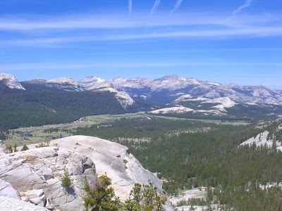
The steep climb to Glacier Point did not rob me of energy as much as it left me floating in an altered dimension. The drive from Yosemite Valley to Tuolumne Meadows in the high country excited me. Across granite chasms, I spied Half Dome disclosing an unusual silhouette from the Tioga Pass Road perspective. Beyond Tenaya Lake looms Mount Conness, the future subject of my attention.

 After an hour’s drive over a rising and fractured landscape, the flat opening of Tuolumne Meadows quiets the sensory disturbance. The lazy, meandering river by the same name drains the alpine grasslands before frothing its way over a series of cascades through the Grand Canyon of the Tuolumne. In the foothills, and still within the boundaries of Yosemite National Park, its fury dies off in the Hetch Hetchy Reservoir. Follow the water: Its precious content is piped to holding tanks around the San Francisco Bay Area before filling sinks, bathtubs, swimming pools and garden hoses.
The tune of an Apache mountain spirit dance and a setting sun ushered us into the cool high country. For our two nights here, I had selected the Tuolumne Meadows Lodge. Or rather, it selected Patricia, Peter and me: It is the only option.
We found it, hidden down a short spur road beyond park employee housing with the flavor of refugee camp barracks. At least these unadorned structures had actual walls. Our lodge is, in fact, described by the park concessionaire as a collection of tent cabins. The odd language pairing is meant to convey a canvas tarp draped over an aluminum frame that shelters four cots. The setup rests atop a cement foundation and resembles what I imagine army tents look like. A table with two candles (no electricity) and a small wood stove (no electricity also means no heater) occupy the middle of the room.
 We settled with minutes to spare before our 8 p.m. dinner reservation. Meals are served family style, which means more than just sharing a table with other parties. The host waits until enough guests have arrived before seating them. The practice presents an opportunity to get acquainted with fellow travelers. It also gives rise to the most expeditious strategy for rounding up dinners. We shared a satisfying meal and conversation with a food purveyor, a plant biologist and an erotica (!) writer.
Before turning in for the night, we had to shuttle between the bear lockers, common bathrooms and our room. It is not just food that must be placed in the lockers, but toiletries as well because apparently the furry animals cannot resist toothpaste and lotion. (Strangely, bears steer clear of the tents used by staff and their toiletries.) Trips to the shower require a visit, in the dark, to the locker before lathering up with one hand while the other presses on the button to maintain a flow of hot water. Reverse the exercise before returning to the room.
Concerned about nighttime chill at 2,700 meters, we came equipped for a winter siege. The canvas cover and drafty seams will not insulate us from temperatures that would drop close to freezing. The wood stove generates sufficient heat but will not last the night. “I didn’t know we were in the Bahamas,” Peter remarks as a roaring fire initially overheats our modest room. I have an extra blanket and a sleeping bag on my cot. It feels as if I have a dentist’s lead vest on my chest. Patricia dons a cap and sinks under the covers. Peter slips inside his sleeping bag.
 I fall asleep reading “Red Racham’s Treasure,” which I remember from my youth as “Le Trésor de Rackham le Rouge,” one of the comic strip installments of Tintin’s adventures. The exploits of the eternally young but ageless, unattached, nominal reporter with a talking dog and of vague residency, attract a loyal readership throughout Europe (and I surmise the rest of the world on account of translations in 79 languages), but my reading surprises Peter. More Americans will get to know the man with the cowlick soon. Peter Jackson and Steven Spielberg are co-producing a Tintin film trilogy that will include “Red Racham’s Treasure.”
 Far from charming or quaint, the drawing card for these utilitarian tent cabins is its prime location in the high country forest. The obligatory familiarity and intimacy with other visitors (à la Phantom Ranch) creates a generous bond. In a culture that privileges individual pursuits, it is a departure to share stories, humor and experiences around the dining table and the campfire.
The lodge also functions as the starting or end point for the wildly popular High Sierra Camps, a network of similarly basic tents set up every 10 km or so, enabling backpackers to hike without, uh, a backpack.
This outdoor and outward communion does not come cheap, sadly. With Peter added at the last minute, the nightly charge came to $90 (taxes additional) for our modest tent. The rate for the High Sierra Camps reaches loftier summits, an absurd $136 per person for shared accommodations that includes dinner and breakfast, hot shower but no heat. A three-night gateway for a couple will set them back $816, doubtless generating a tidy profit for DNC.
After more than a quarter century in the U.S. I have abandoned my assumption that the public trust should not be a for-profit proposition long ago. But does it have to be so flagrant? This surrender to greed is most damming in a national park where contracts are subject to bid, with the lowest, one expects, gaining favor.
The High Sierra Camps have a loyal following, a group for whom $200 a night for a tent (the non-food part of the rate) for two represents a fair, if not excellent, value. Even under ideal financial conditions, I could not bring myself to cough up this kind of dough. There is a tipping point where the experience surrenders to the attributes, and the High Sierra Camps devotees zoomed past it long ago.
Is this mentality inevitable?

 Seven refuges cling to the steep slopes above Chamonix, the archetypical mountaineering destination at the foot of the Mont Blanc. You may need to ride tramways or gondolas, hike or traverse across glaciers to reach the wood or masonry chalets and farm houses. They can be viewed as local goals or components in a mountain hut network that reaches across the Alps.
The nightly rate during summer includes dinner and breakfast and goes for 46€. Members of the Club Alpin Français (65€ includes optional rescue/evacuation insurance) pay 35.50€. In winter, the no-host shelters cost 6€ on the honor system.
In the Aravis Range above La Clusaz and near Geneva, the full price at the Refuge de la Pointe Percée is 40€ (night only: 15.75€; CAF members: 34€/7.75€ respectively). In winter 12€ includes firewood and gas.
Similar arrangements exist on the other side of the border in Italy and Switzerland, countries with strong mountaineering cultures. The CAF also operates chalets within ski resorts. An overnight at the Centre National de l’Eychauda near the base of the “small” Pelvoux ski area in the imposing Ecrins Range runs 35.30€.
My hypothetical Yosemite couple can scale Europe’s tallest mountain (ok, I am not including Russia, sorry) and pay 276€ for the three nights. Even with a super weak dollar, this comes out to $375.
Rates outside of a world-class destination like Chamonix are even less. All the people you will meet, from front desk to housekeeping, lifties and ski patrollers, retail and restaurant staff will have health coverage and vacation benefits. (The French minimum wage comes to $11.16 hourly, indexed every year without having to ask permission from politicians. It is the same in the UK and higher in Luxembourg and the Netherlands, three of the continent’s most dynamic economies. GDP growth for 2007 is forecast at 2.2 percent in the US, 2.4 percent in France, 2.8 percent in the Netherlands and in the UK, and 5 percent in Luxembourg. We are always told that higher wages hinder growth: Enough already of this outmoded model.) I find it sickly bizarre that we accept high prices and simultaneously refuse to impose minimum labor standards.
The price disparities extend to winter activities.
The Pelvoux ski area charges a measly 15€ ($20) for a lift ticket. Mammoth Mountain, with a similar vertical drop but more lifts, asks for $78.
Lest you think the price advantage favors smaller hills, compare Val d’Isère, a resort with 300 km of runs, 89 lifts and a 1,451-meter vertical drop, statistics that no US resort can match. Peak passes are 42€ ($57).
Even more massive, Zermatt’s exceptional 2,200-meter drop on the slopes of the Matterhorn dwarfs all mountains in the world. Bring CHF70 ($57) and it’s all yours, unless you prefer to ski in Italian from Cervinia in which case you’ll get 1,475 meters (only) and pay 34€ ($46) per fare la dolce vità on the flip side of the Matterhorn.
This past winter I discussed pricing strategies with a representative from Switzerland Tourism. She stated that it is cheaper for U.S. residents as far west as Chicago to fly to Switzerland for a ski vacation rather than go to the Rockies or California. Beyond the lift tickets, all incidental costs – lodging, travel, food – are more expensive at U.S. ski resorts.
In the mood for something even more radical?
Colorado’s Silverton Mountain not only limits drastically the number of skiers on its powdery slopes. When conditions are best, from mid-January until early April, you will need a group guide to explore the mountain’s chutes and bowls. According to their Web site, you do not need avalanche training, but you must bring a beacon, probe pole and shovel. (If you don’t know how to use them, I am sure they still look pretty…). If you don’t own the gear, add $30 to the $129 lift pass.
When in doubt, go higher.
To gain some stability, we followed fissures and wedged our hands and feet in the cracks. Walking on weathered granite gets a little slick at times and it is unnerving to find oneself dangling with no anchor point. Very quickly, the views of Tuolumne Meadows opened up to take in the Cathedral Range, Kuna Crest, and innumerable canyons and valleys dropping off the Sierra Nevada’s east rampart.
 Stepping off the trail, intentionally or not, is also quite liberating. This cross-country route (class III) is fun.
Near the top, I heard voices above us and it wasn’t God. A trio of climbers were nearing the summit and had come on a different route. The trail does exist after all! We took a break and got friendly with a chipmunk that exhibited no fear.

 For practice, I picked the most difficult line down. We stayed high on the spine of Lembert and located the trail when we spotted a hiker. He turned out to be from Italy and showed me the way back on his map – che piacere! Because it was so close, we detoured to Dog Lake. We walked on the morning’s absent trail but instead of leading us to the parking lot, we arrived at the road as Peter predicted. I have since studied a topo map and still can’t figure how that happened.
  With Patricia, we spent the afternoon on a long walk along Parker Creek and the base of the Kuna Crest. Appropriately named Mammoth Peak marks its terminus. Mounts Dana and Gibbs frame the valley and form Yosemite’s boundary.
Our original goal was Mono Pass, but after meeting with a ranger, we changed our target and aimed for Spillway Lake instead where he said he could “park his butt there for a lifetime.” An Inyo National Forest Service employee, I accused him of trespassing on Department of the Interior lands. He had just returned from erecting signs for the Ansel Adams Wilderness that begins at Mono Pass. (This is not the same Mono Pass out of Rock Creek that I climbed in preparation for Mount Whitney.)
Other than tips on where to park one’s behind in suitable surroundings, I learned that Saddlebag Lake Road had opened that morning – finally! Great news for tomorrow’s adventure.

 I asked both Patricia and Peter to identify the waterfall that plummets above Spillway Lake but they could not pinpoint it. “It is not Niagara,” confirmed Patricia.
The ranger had suggested a cross-country route to Parker Pass, but as alluring as his depiction was, this new destination would have increased the distance by half. Peter was feeling the altitude (3,000 m) and walked slowly.
I stayed high above the creek and proceeded cross country over snow patches for the beginning of the return journey. I saw a few deer but not a single person for the length of the 7-km trail.
 To vary our pleasures, we dined at the Tioga Pass Resort, just a few minutes outside the park’s Tioga Pass entrance. Its diminutive dining room accommodates no more than a dozen people. Our waitress had moved directly to Lee Vining, down canyon, five years ago from Tokyo. I can’t imagine a greater contrast. No daifoku or Calpis for you, my dear.
Unlike our Tuolumne Meadows Lodge, TPR boasts of real log cabins, but at twice the cost. When the road is closed for winter, someone comes down to the gate across the highway and drives guests to the snow line. From there, they have to snowshoe of ski their way to the cabins. Why would someone want to come here when everything is, by definition, closed?
To explore all these snowbound peaks, cirques, chutes and meadows!
Again, this is a pleasure for the well-to-do. The cabins fetch $160 or $290, for one or two persons. Dorm beds (no linens) are $140. These rates include dinner, breakfast and a sack lunch. Because of the isolation, it is impractical to show up just for one night for much time will be wasted simply coming and going. As much as I want to go ski touring, I would be sick to my stomach to pay three hundred bucks for a bed without sheets!
The roaring outdoor fire set off ghostly and warm figures. A man apologized for a supercilious supporter of military force who I assume had debated his perspective a little too forcefully around the dinner table. His vicarious act of contrition was directed at a group of British visitors who indeed might have taken offense to the chap’s bloodthirsty rhetoric. His public mea culpa endeared him to my leftist sensibilities that are sometimes portrayed as extreme in this land of invisible middle. My observations and commentaries chart a moderate discourse compared to his accusations.
I am not alone.
A member of the UK contingent with a melodic accent hailed, of all places, from Franche Comté. She shared her journey from a small French village with few windows to the outside, to life in Manchester and world travels. Her blossoming desire to seek the other, to reshape personal visions resonated in my own history. In February 1973 I flew to London with my sister for my first trip abroad and on a plane. I was 12. it changed everything, and not just because I noticed that the sun did shine above the gray winter skies.
 The night wind slapped our makeshift home and the creaking of a violated stovepipe woke me. From my horizontal vantage point, I studied the flapping canvas and calculated the potential damage of a collapsing tree limb. I wanted to use the bathroom, but refused to extricate myself from my warm carapace. I returned to sleep, intermittently awaken by new howls.
At morning breakfast I sat next to two West Point cadets. I half expected them to be more intransigent than tolerant, fervently imbued with problematic notions of patriotism. The sight of a t-shirt with a Canadian flag told me this was no flag-waving bunch. At the end of their freshman year at the military academy, I respected their unprejudiced and even analytical standpoint. Their basic training anecdotes entertained me. Their disappointment at the absence of character in several cadets surprised me. They had arrived at the lodge after hiking the 50 km of the Grand Canyon of the Tuolumne. Quite cool!
I have never supported the war in Iraq. I hope they will never go there on duty. And I certainly hope their names never join those on the long casualty list of their misguided leaders.
And on the subject of misguided: Patricia’s table neighbor asserted that my sensitivity to cold was most certainly dude to autism.
Patricia treated Peter to breakfast for his 36th birthday. I had picked a bottle of Unibroue’s “La Fin du Monde,” a triple fermented ale with a nine percent alcohol content from Québec. “That’s what I need,” he said as he left us to return to his Bay Area home.
I trust he waited to get home before popping the cork.
[[[ Ξ ]]]
Patricia woke up sleepless after a night interrupted by the repeated yakkings of motel guests who perceived the outside corridors as a great place to engage in a (loud) conversation.
We overnighted in Fresno on an undistinguishable thoroughfare in an unremarkable city. The view from our second floor room presented us with an abandoned boat in an empty parking lot fenced with barbed wire.
Patricia had spent several weeks in Louisiana tending to her ailing mom and itched for an outdoor adventure that would take her mind off hospitals, medications and syringes. We took a day trip through Cuddy Valley to Mount Pinos and Sawmill Mountain, two adjacent peaks at about 2,700 m on the San Emigdio Range stuck almost on top of the San Andreas Fault. It is a great Southern California outing, pine trees and all, but the Sierra Nevada it is not, and a visit there, doubtless, would fill Patricia’s head with more impressive images. The Fresno motel was but a hurdle in the direction of the high county.
 Before hitting the road, we stopped for coffee at Starbucks. Difficult to come upon an independent coffeehouse when you don’t know your way among the homogenized and pasteurized cityscape. I was goofing around with Patricia when a customer overheard my comment about taking the bus for an appointment with my hairstylist.
“Why?” she proclaimed in a voice that betrayed her puzzlement.
You may wonder why someone would ask why. Outside of selected urban areas, riding public transit in the U.S. borders on the political. No one in their right mind would chose to take the bus. No one except those who have no choice. Even in my enlightened city, the bulk of riders are mostly minorities, young or elderly, poor and possibly handicapped. Students are well represented because the two local colleges force them to purchase a pass as part of the tuition.
The reaction of the Starbucks customer was not unusual. Public transit is not for our kind. It’s for them - never mind our professed concern for the environment.
A little over an hour later, I flashed my annual pass for free admission into Yosemite. I am starting to question whether Patricia’s gift is steering my outing decisions. This is the sixth national park with an entrance fee that I have visited in the last three months.
The National Park Service wishes there were more people like me. The decline in park visitation noted at Death Valley, Zion, Bryce, Capitol Reef and the Grand Canyon accentuates at Yosemite. Between 1996 and 2006, the park lost 803,563 visitors, a drop of nearly 20 percent. When you factor population growth, it is a drop of nearly a third. Let them play video games!
The hotels in Yosemite need not resort to promotional offers to get back these (presumably) unhappy campers. The park hosted 3,242,644 visitors last year. Because of the finite number of rooms available, the competition between beds and travelers is in favor of the former on most nights. Translation: staying in Yosemite for the night costs more than similar digs elsewhere.
With a few days to spare, Peter checked his e-mail and managed to score some free time to join us. The challenge rests in putting together a trip that will motivate three people with different, if not diverging, interests and abilities. Peter has never visited the park; Patricia and I have made the pilgrimage dozens of times. She prepared during the last couple of weeks by running up stadium stairs; Peter’s heel bothers him and hurts when he hikes.
He was able to arrive in Yosemite a day early and get his bearings. Fondly appreciative of Sequoia/Kings Canyon, I suspected he would find his way to the Mariposa Grove of the giant trees.
 Emerging from a tunnel, the landscape suddenly contracts to expose the steeply encased, glaciated valley. Bridalveil Fall figures prominently in this first portrait, a graciously fluid counterpoint to the intimidating big wall of El Capitan. Yosemite Valley is where the park’s waterfalls, its showcase attraction, reside. Half Dome stands guard over Yosemite Valley and the Merced River. Its iconic profile is the park’s most recognized landmark, made illustrious in Ansel Adams’ stark black and white photography. It shows up on the reverse of the California quarter, with a gazing John Muir. The advocacy work by the naturalist led to the protection of this area in 1890.
 Fifty years ago this month, three rock climbers conquered Half Dome’s 600-meter wall after five hair-raising days. The hike to the top ranks as one of the country’s classic adventures. It is a long (26.4 km round-trip) and difficult (1,462 m) climb that ends in a vertiginous ascent using cables raised on poles bolted into the granite face for hand holds. Absolutely, uh, gripping! I chose to climb it several years ago as my first hike after the trouble to verify that I was still in decent shape, at least physically. In our first conversation, Eric told me that he, too, had climbed it, a feat that immediately situated him in my mind.
Today, I had my eyes set on another signature hike. Patricia and Peter paired up to hike the Mist Trail to Vernal and Nevada falls on the initial approach to Half Dome. I set out to climb to the Glacier Point overlook, a magnificent viewpoint that takes in all of Yosemite Valley and the backcountry. It is justifiably popular with sightseers who drive the 40 minutes from the valley floor. I thought it would be neat to walk there.
Guide books feature a narrative for the downhill hike, somehow presuming no one would be foolish enough to want to hike up. Going to Glacier Point required that Patricia and Peter drive there to pick me up afterwards – a proposition that triggered logistical headaches. Determining a rendezvous time proves tricky with too many uncontrolled variables and an overall desire to get to our lodge before sunset.
We sought information on the Glacier Point shuttle but I could not make the last trip down is at 3 p.m. (why so early?) and was not too keen on spending $20 for the privilege either. In truth, this is not a shuttle but a tour operated by Delaware North Companies, the outfit that won the concession to operate essentially all of Yosemite’s lodges and activities. (DNC runs a host of entertainment, gambling, food service and lodging destinations, all very much for-profit ventures.)
The park does have free shuttles within the valley and at a couple of other locations. They are intended primarily to cut down on traffic (which once reached epic proportions in the valley) and not as conveniences. By definition and inclination, national parks are “where buses don’t run.” A bus line runs from Merced (120 km, $13) in the San Joaquin Valley to Yosemite Valley, where it connects to another bound for Mammoth Lakes (160 km, $15) in the Eastern Sierra. Both routes are for more economical than the Glacier Point gig. They make one-way trips between Yosemite Valley and Tuolumne Meadows in the park’s high country, or better still, long hikes on the John Muir Trail, feasible. I picked up a trail near the chapel, but it was a 2-km connector before hooking with to the Four Mile Trail that I would follow to Glacier Point, straight above me. It goes up the valley’s south wall, but I can’t make it out. Yes, there is a chapel in the valley – and a cemetery and a jail, among its more unusual amenities.
 Early afternoon and plenty warm. The trail climbs directly opposite the three-tier Yosemite Falls. Its combined 739-meter drop from a hanging valley is the highest in North America. The Falls keep me company. As soon as they disappear behind the corner of my eye, a switchback repositions them front and center. The Merced River recedes and becomes but a braid of water squeezed by the Cathedral Spires and El Capitan. I notice rafters and I fantasize it would be nice to float along. Maybe dip into, although I am no fan of frigid waters.
El Cap is the standard for big wall climbing. Lost World, Hole World, Realm of the Flying Monkey, Lurking Fear, Never Never Land, Pacemaker, The Reticent Wall, Surgeon General, Plastic Surgery Disaster, Get Whacked, and Chinese Water Torture are a few of the descriptive name for the routes up the one-kilometer face. The Nose is a sublime route rated 5.13b.
Sublime of terrifying. Speed climbing motivates those for whom a simple big wall does not represent enough of a challenge. Hans Florine and Yuji Hirayama climbed the Nose’s 32 pitches in 2 hours, 48 minutes and 50 seconds last year.
Of course, there’s always free solo…
And there was BASE jumping, which NPS forbids. In 1999, Jan Davis, a Santa Barbara stuntwomen, died while making a protest jump from El Cap in support of lifting the park's ban.
No real risk of sliding off the trail for me, although it travels near the edge. To gauge my progress, I asked the few people hiking down whether they were coming from the top and how long it took them. My spirits perked up when a bare-chested young man confided he had started 10 minutes ago. Unfortunately, the next hiker to cross my path volunteered it took her 30 to 40 minutes. A few minutes later, my next interview yielded a reply of 45 minutes. The more I walk, my destination gets farther and farther away!
I pressed on and was happy to exchange my Yosemite Falls views for Half Dome. The new vista indicated my goal was getting closer, notwithstanding the questionable assessment of my fellow hikers.
Ever observant, I noticed several people on a promontory in the far distance. Their motion distracted my eye and I assumed they were hikers coming down. When I saw an Oregon couple making their way down, I updated my familiar query.
“Is that, uh, Glacier Point?” I said. “Yeah, yeah, you’re almost there,” they replied. A bit elated, we chatted for a while and exchanged notes on Half Dome, Phantom Ranch and Mount Hood. For the Mount Whitney hike, I had created a chart to predict my overall hiking time by factoring elevation and rate of ascent. The Four Mile Trail has been elongated to 4.8 (7¾ km), presumably to make it a little easier. Trail builders did not lower Glacier Point, and it is still a 980-meter climb from the valley floor – a mirror to El Capitan. The calculations budgeted 2h52 but I shaved almost an hour off of it.

 With a big grin, I nonchalantly walked to the Glacier Point overlook where small crowd assembled for the obligatory pictures. I enlisted a friendly and witty African American family for my own posterity recording.
In the distance and below me I saw the twin ribbons of white water from Vernal and Nevada falls. Surprisingly I was able to call Patricia’s cell phone. Surprisingly, too, I learned they had not yet reached the top of Nevada.
Under the best scenario, it would take them three hours to get to Glacier Point. I did not want to wait that long. After a leisure break I scouted the parking lot to hitch a ride from people returning to the valley.

 Dads Dennis and Mark were returning to their Bay Area homes with kids Adrian (10.9836 years old) and Eleanor (9 years old) after a few days in the park. Their car had a GPS that attracted my attention. Eric and I made good use of his when we went on our CA-NV-UT-AZ-NV-CA adventure. The elevation reading was somehow way off.
Eleanor said she and her dad Mark also made good use of it when they traveled to Ohio. Any mention of that state and my ears prick up as if permanently tethered to the events of November 1999. It turns out that Mark hails from Dayton and knows of Prebble County. How could he not? I asked him when he left his home state and his replied assured me that we shared a certain understanding.
“The Sunday after my 18th birthday.”
He is in his late thirties now, but some stuff you never forget. Mark once hiked the Four Mile Trail but was bummed to realize you could drive there. He’s also made it to Half Dome twice, if memory serves.
Our conversation flowed lazily, evocative of the casual solidarity that animates old friendships. Except that in this case, mere minutes defined it. We were relaxing at a café with constantly rolling outdoor tables offering us a moving panorama. Glacier Point’s promontory faded in the rear view mirror as we dipped into a red fir and lodgepole pine forest. The GPS magically corrected itself.
Adrian and Eleanor gave me a potato chip and explained what skiing fries and pizza entails.
I wished Adrian a slightly early happy eleventh birthday and left Eleanor, who was learning Spanish, with a ¡que te vaya bién! Dennis and Mark went out of their way to drop me in the valley. They could have taken me, somnolent, out of my way, anywhere. I don’t think it was simply the exhilaration of the hike that made this journey memorable – or even the beer that concluded it. Like Blanche, I have always depended on the kindness of strangers.
I sank my toes in the chilly Merced River to nudge me to reality. I thought of the beached boat in a dingy Fresno parking lot. I pictured it sailing the meter-deep Merced and charting a course away from the sterility of its exile.
All hands on deck. This is an emergency.
