 I woke up at 3:45 a.m., agitated with worry that a full day would not be enough to make it up to the top of Mt Whitney and back. This is the day of all days. I am charged! In San Diego the prior week, I had met someone who "did not see the point" in climbing a mountain. I wish I had replied to this tennis player that I didn't see the point in a fuzzy ball going back and forth, but I actually like tennis!
To hell with him - me goin'.
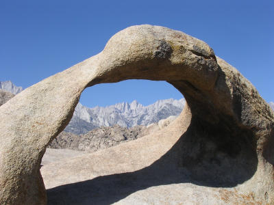
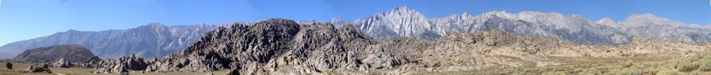
Above is a nine-picture composite creating a panorama of the Sierra Nevada in Eastern California. Mt Whitney is not the mountain that appears the tallest, but slightly to its right. The picture (which - as all may - be viewed in a larger format by clicking on it) shows the mountain range from the Horseshoe Meadows road (left) north to Onion Valley. The Alabama Hills parallel the range, as does Hwy 395, the arterial connector for all the communities in the Owens Valley, where the pictures where taken. The mountains drop about 10,000 feet/3.000 meters to the valley floor in less than 10 miles/16 km, creating a continuous collection of impressive, steep canyons. The climatic and biotic zones likewise undergo an extreme adjustment: the Owens Valley lies in the Great Basin desert [temps around 100 F/37 C], within sight of permanent snowfields.
My kind of place!
Getting to the top of a mountain induces a certain euphoria that I trace to thin air, of course, and my general instability. The challenge of fighting gravity motivates me, oddly as I typically think of myself as noncompetitive. The physical effort forces a suspension of the mind, of earthly thoughts, and that is an irresistible bargain. Transcendent meditation for the uninitiated. I don't have to ackowledge reality.
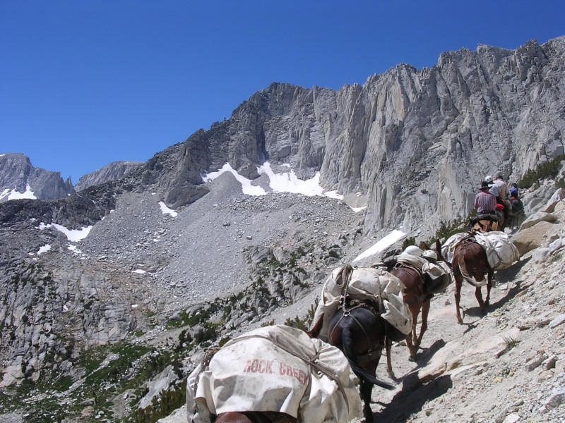
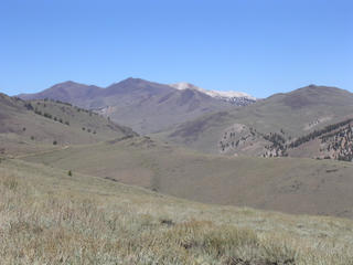
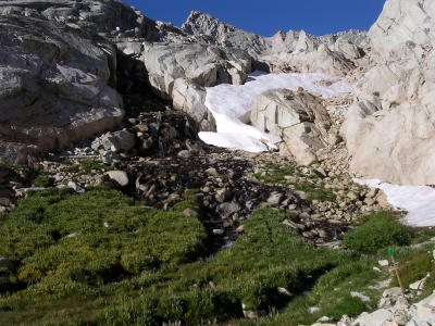
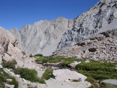
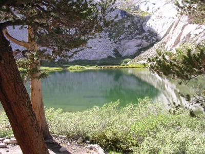
Even though I am a strong hiker (to say nothing of my skiing abilities eh eh) and more recently have worked on specific strength and flexibility goals (the latter not quite achieved!), climbing up the 2,462 feet/750 meters to the top of Santa Barbara’s Montecito Peak is good conditioning, but it is sea-level conditioning. I saved a couple of days for a few hikes above 10,000 feet, and revisited Rock Creek out by Tom's Place (the name of the settlement, not someone I know). It would be so cool to go on a pack trip. But I managed to get to Mono Pass (12,000 feet/3.655 meters) on my own power, where I peeked into Neelle and Trail lakes, and played in the snow.
A guy from Knoxville, Tenn., backpacking with his friend from Marin County (yeah!) took my picture.
 We talked for a bit about Tennessee...
Getting a sense of distance on those wilderness trails requires some investigation. Trailhead signs warn of bears, dehydration, solar refraction, but curiously omit what I tend to view as critical information. No map or trail sign indicate how far landmarks are. It became a game to ask hikers how far Mono Pass was. No one knew! At the Inyo National Forest Ranger Station in Mammoth Lakes, I engaged in an animated conversation with ranger Mike Johnson who unflinchingly said hikers should do some research before setting out in the wilderness. “It’s very reasonable not to have mileage information,” he said. Hit the books, baby!
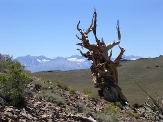
Near Mammoth Mountain and already dreaming of winter (who’s thinking about skiing?? Count off the days until November 10!), I passed beautiful Skeleton (yikes) Lake. On the other side of the Owens Valley, high in the stark White Mountains, I tripped around an ancient (3,000-5,000 year-old) bristlecone forest. These hardy trees survive fierce winters and brutal winds.
Sandwiched between the Sierra Nevada and the White and Inyo Mountains, the narrow Owens Valley stretches for several hundred miles from the Haiwee Reservoirs to Mono Lake. The towns cluster along the thin ribbon of riparian greenery
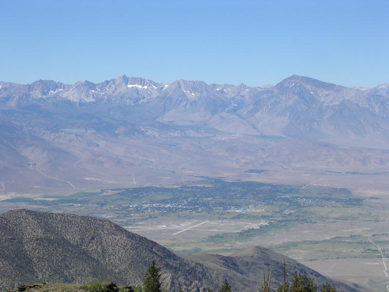
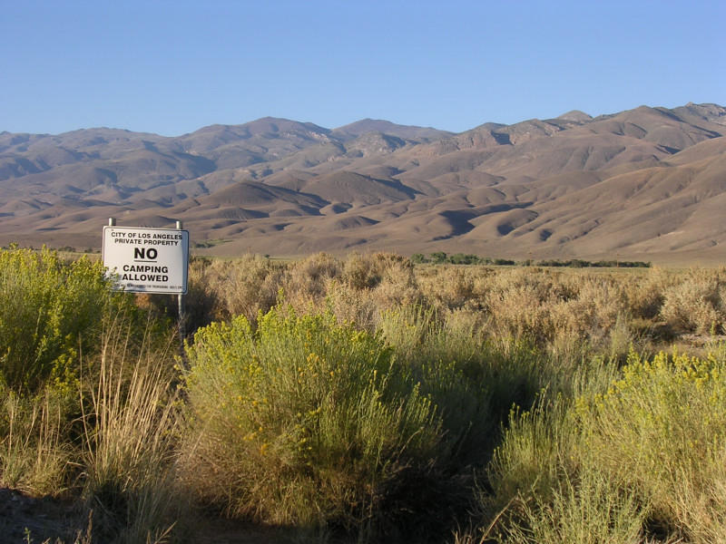
created by the Owens River. The city of Bishop – all of 5,000 inhabitants - is a hub of sorts. This river, and the water that is not in it, provides a regional social identity up and down the valley. Land use and economic expansion hinges on its consequence and ultimate benefit to the area’s largest landowner. Look at the sign in the middle of the rabbitbrush and shadscale for a clue as to who these folks might be. If you want to know why Owens Lake now sits mostly dry whereas it once was California’s largest lake, check out Roman Polanski’s Chinatown for a primer on the role of water in Western politics. Or visit the Save Mono Lake people out in Lee Vining.
The spaciousness of the Eastern Sierra - of the Western United States - envelopes me. The landscape oozes over a vast expanse: Fill up the tank - don't expect public transportation here either! By "next services" they mean gasoline stations, but don't imagine there will be much action of any sort for the next 97 miles/156 km in any event...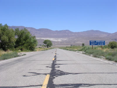
The parking lot at Whitney Portal was full, but eerily quiet and ominously dark at 5 a.m. I was expecting a beehive of activity but saw only a few parties gearing up for the climb. I scanned the neighborhood widely with my flashlight for the trailhead and found it behind displays that explain the ecology of the canyon, a constricted affair drained by Lone Pine Creek. In contrast to the furnace of the Owens Valley, the predawn temperature hovered in the low 50s F/10s C. In preperation for my longest and highest hike ever, I had nearly memorized each curve along the 11 miles/17¾ km to the top of Mt Whitney during my research. To calculate with precision the length of time I would need before I could perch myself at 14,496 feet/4.418 meters, I studied the rate of ascent for each segment of the 6,136-foot/1.870-meter ascent. Inyo National Forest Service rangers predict 16 to 18 hours for the round-trip journey, a considerable proposition forcing a departure and return in the dark. A cute “It’s a Long Way to the Top” printed on a simple sheet of paper set the persimonious tone.
Burdened with a backpack jammed with enough food and beverages to open a small restaurant, and a change of clothes, I entered the dim forest. Immediately, I started to wonder whether the durability of Duracell batteries would rise to the occassion.
Shortly, I turned my flashlight off. What seemed profoundly tenebrous 10 minutes ago now revealed a distinct shape. Ahead, I noticed beams of lights boucing around and decided I would piggyback on these good people's source of light.
As I caught up with them I remembered seeing them leading a prayer circle at the trailhead. We compared our respective preparations for the climb. I became somewhat despondent upon hearing their many exploits and cursed that I had not climbed into and out of the Grand Canyon, nor strained up and down countless High Sierra peaks.
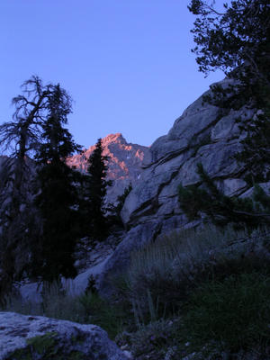
I was going to fail miserably but I seized upon a pause to pass the Group of Six and headed forward on my own. When the sun rose above the eastern sky, I took this picture of the first rays bathing Thor Peak.
In a matter of minutes, the canyon was illuminated. Seeing where one walks does wonder to the momentum forward! I forded Lone Pine Creek on a strategic arrangement of boulders and logs, greeted a family of grouse on an outing, strolled through Bighorn Park to wave the campers at Outpost Camp good morning.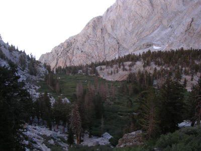
Getting to Trail Camp, barren in its alpine setting at just over 12,000 feet/3.655 meters and, I suspected, windswept on less marvelous days, brought me face-to-face with the next goal and the final one. Had I not had this heavy backpack, I would have jumped for joy. Several campers ambled around barefeet and soaked in the potent high-altitude sun in this serene spot. Wedged between Wotans Throne and Consultation Lake, the camp’s location affords an eagle eye’s view of the canyon down to the Owens Valley. Before the concluding assault to Trail Crest, I opted to hide a bottle of water and a Red Bull to lighten my uphill load. After a marmot surfaced to investigate my cache within seconds, I secured it with a few well –placed rocks. Marmots should not pilfer energy drinks. Carry your own, buddy.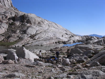
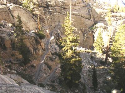
The relief at reaching the camp lasted two, maybe three, switchbacks on the way to Trail Crest. Faced with nearly 100 such hairpin turns and oxygen more tricky to extract, I reasoned I could take small breaks every 10 switchbacks. The trail zigzags continuously up the talus slope, sometimes soggy from melting snow, sometimes frozen with ice. I reconsidered and stopped much more frequently. Can you tell where the hiking party is in this picture? One feels a little tiny up here. But also like a giant.
The trail floats upward. Cables are set up in one particularly steep section to ward off a potential fatal fall. I encountered many hiking parties that had stopped for a break, appearing on the brink of collapse. In conversations between heavy breathing, I realized most day hikers start off between 1 a.m. and 3 a.m., thus explaining the low level of commotion at the trailhead when I showed up. The Inyo National Forest issues 100 daily and 60 overnight permits to regulate and control access. Green tags attached to backpacks identify day hikers, whereas yellow ones identify overnighters. Campers have two choices and much more time to trek to the summit. Framing the view and constraining thoughts, Mt Muir, the Needles and Mt Whitney stand out against the clear sky and look down on the human drama being played out below.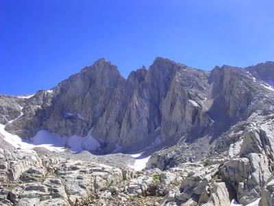
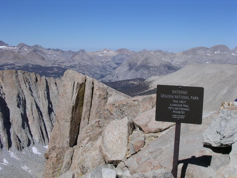
The Trail Crest sign greeted me as I filled with exhilaration. I settled on a boulder with 360-degree views for an early lunch. The main course consisted of homemade trail mix (a careful balance of raisins, cranberries and walnuts), immediately followed by a desert of banana and orange. At this 13,377-foot/4.077-meter mountain pass, the trail officially enters Sequoia National Park. This achievement caused a minor celebration. Until then, the highest place I had ever walked on was New Mexico's Wheeler Peak at 13,161 feet/4.011 meters.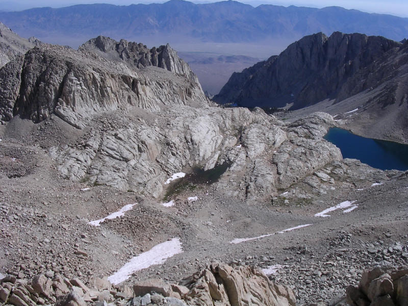

The entrance to Sequoia lies many miles away and the famous trees are not anywhere near. The views now take in the park’s rugged interior, including the Hitchcock Lakes below the audacious hiker. To reach the top, the trail will now traverse west-facing slopes, with occasional views of the Eastern Sierra glimpsed between the jagged Needles, which stand as mere indentations of the ridgeline viewed from this side.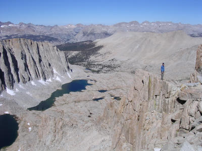
The final leg to the top of Mt Whitney is a mere 2½ miles/4 km. At this point, the sadistic trail builders dropped it 300 feet/90 meters to a junction with the John Muir Trail, only to have it head uphill once again for a final punishing 1,016-foot/310-meter ascent. Until then my pace was about 15 minutes behind what I had estimated. Nearing the goal, hikers proceeded in slow motion, each step weighted down by the twin burdens of distance and altitude. Descending hikers, on the other hand, exulted joy in their relaxed descent. I met a 7-year old girl and a 9-year old and 11-year old boy. They were overnighters, but it is still quite an accomplishment to conquer Mt Whitney at that age. I also met a man in his late 60s on his second trip up the mountain. I find their rejection of self-imposed age limitations and commitment to crisscross these massive boulder fields quite inspiring. 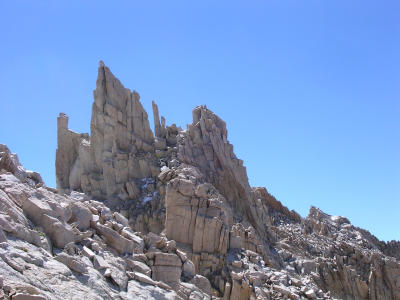
Near Keeler and Day Needles, I posed for my trailside Japanese friend who laughed when she saw I was holding an Asahi beer. She hailed from Davis, oddly as so many other hikers that day. 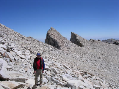
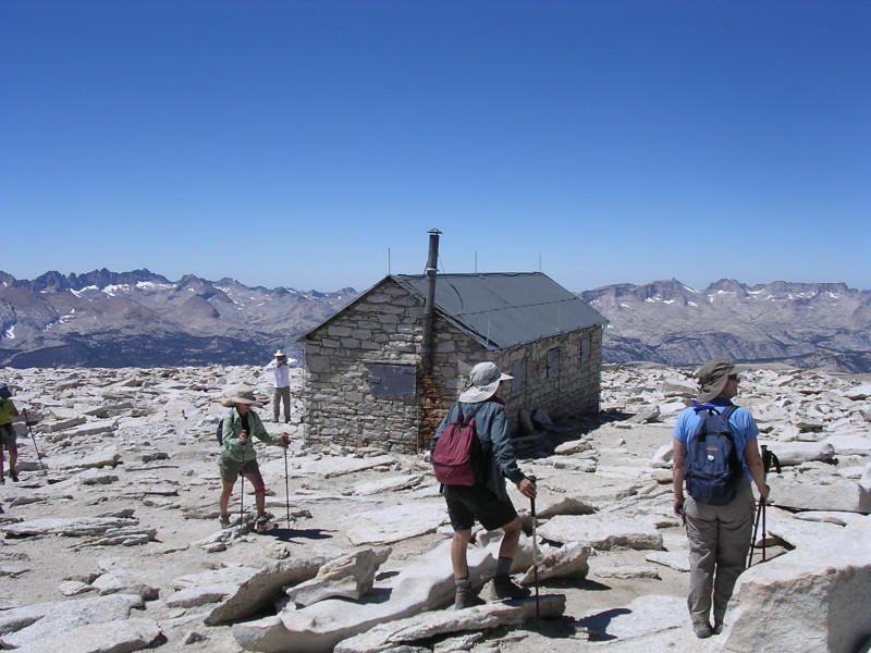 After an hour and twenty minutes, I arrived at the summit hut a full seven hours after setting out in the predawn darkness. The final leg took an hour and 20 minutes. In my excitement, I did look at the trail register but forgot to sign it!
People were eating, chatting, joking, calling others on cell phones. From a certain spot nigh above the deeply dark green waters of Iceberg Lake, a faint cellular signal made calls possible. I called my mom in Paris and Elisabeth in California. With one leap, I could get to the lake in a hurry!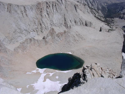
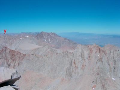
The views encompass so many peaks that it is a challenge to identify them at first. Strangely, the first (white) explorers had similar trouble. It was only on August 18, 1873, that local anglers reached the summit after three previous attempts since 1864 had scaled the wrong peaks! Climbers got to the top of (what we know now as) Mt Langley [x] to the south and Mt Tyndall [y] to the north. 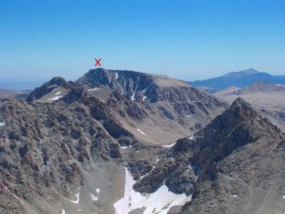
A California Geological Survey party named the mountain in honor of the head of that society. They spotted it, but did not climb it until after the local fishermen. For years, Mt Whitney was called Fisherman’s Peak, and despite a legislative vote to make that name official, the usage endured and nowadays no one ever calls it that.
The elevation itself seems fluid. Some guidebooks have it as 14,494 feet, my topographical map states 14,495 feet, local postcards claim 14,496 feet and the Forest Service sees it as 14,497 feet!
Regardless, I figured I ought to do something to stake my own record. I asked someone to take a picture of me while jumping above the country’s highest peak (sorry Alaska, you don’t count). It took eight tries during which my head or feet would get cut off, but I almost made it unscathed on this one! A foot above the rest of the world.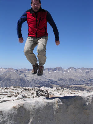 (Or when 14,496 feet is not enough!)
After an hour and 15 minutes of jumping around, interviewing a few people (an article in the works) including a dude from the Orange County (Calif.) sheriff’s department who was smoking a celebratory cigar, I left the summit, sadly. For a few minutes I could not locate my sunglasses. I remembered leaving them with my backpack, a backpack that had become a source of amusement for an inquiring marmot. I thought it had taken off with them!
I came across many of the same people I had passed in the morning on the way up. Recognizing me, they asked for validation of their struggle.
“Another five minutes, I swear, you’re almost there!”
“Just around the next curve. Don’t give up!”"I’d say about 15 minutes from this point. Take it easy, ok?”
“It shouldn’t take you more than half an hour. Take some breaks; drink anything!”
“Umm ... well, I am thinking maybe, like, uh, an hour??”
Just past the intersection with the John Muir Trail, a young woman stepped aside to let me pass, saying she was tired and needed a break as the trail was going uphill now. I told her I understood how taxing such a climb is. She quipped it had taken her 18 days.
What??
This lady had just hiked the John Muir in its entirety, some 200 miles from Yosemite. I almost kissed her! I assured her that once at Trail Crest it would be all downhill and she was only 8½ miles/13½ km away from civilization, should that be reassuring. After days in the wilderness, returning to society sometimes triggers withdrawal symptoms. She had no idea of the catastrophe that was unfolding in the Gulf Coast. I didn’t tell her.
I introduced her as a heroine when we reached the pass and continued down to Trail Camp. (Do you think someone could have been a tad more creative in naming those places?) I retrieved my drinks and noticed the rocks had been moved. I took the opportunity to change into shorts and a shirt and headed down at a brisk pace.
No one would be headed uphill now. It was a bit past 2 p.m. and it would be foolish to give the summit a shot this late. Lighting is common, and it would be hellish to be caught in a storm up there. (Lighting strikes mid to late afternoon, for those who wonder about the timeliness of the comment…)
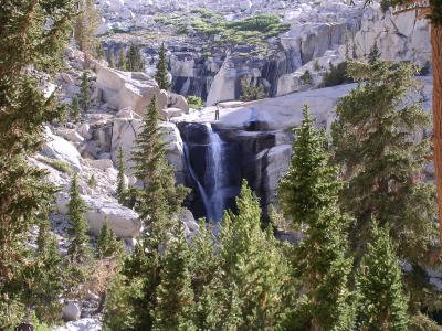
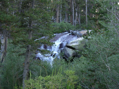
I got a chance to see what the morning’s darkness had shielded from me. Mirror Lake sits just above Outback Camp, as do the two waterfalls. Notice the hiker at the top of the first one. Traveling in the midst of Foxtail, Lodgepole, Jeffrey Pines and Red Fir – in descending order – feels very cozy after the emptiness of the alpine expanse.
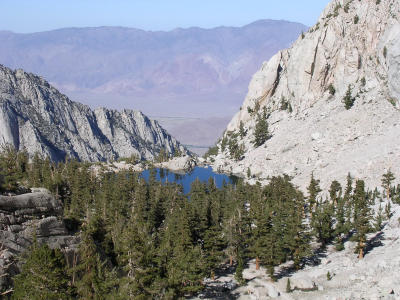
The trail skirts Lone Pine Lake but on the approach, it is plainly visible in a V-shaped cleft, seemingly hanging above the Owens Valley Floor. Above the lake, the area is part of the huge John Muir Wilderness, a protected area that extends all the way to Mammoth Lakes and covers 584,000 acres/2.363 km² - 3/5 of Rhode Island or 22 times the size of Paris. It was 4:40 p.m. when I took the picture (thanks digital imprint) but the setting sun was already partially obscured by the wall of the Sierra. The light was magically soft, quite unlike its harsh intensity when it was directly overhead at the summit.
The angle of the shot makes it a little difficult to get a sense of how the Civilian Conservation Corps constructed the trail’s many switchbacks, which number over 200.
When I spotted the parking lot, I rejoiced at my accomplishment. It took me four hours to come down, for a total of 11h15mn. I am quite happy with that! I took off my boots and socks to take a dip in the creek, but these glacial waters ain’t too warm!
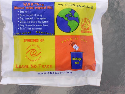
The trail's popularity has the potential to generate a big mess. To avoid unsightly piles, to say nothing of the environmental degradation, the Forest Service provides "wag bags" for visitors to carry their (human) waste with them. I expected an ocean of such bags dangling from backpacks, but only saw four with a group of overnighters. When they say, "Leave no trace behind," they mean it.
I hung around Lone Pine another day to .. go on other hikes! 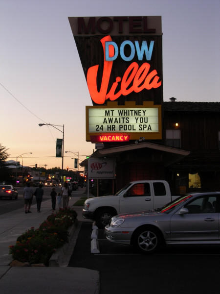 At the Dow Villa, I ran into the Group of Six who told me they got back down at 9 p.m.
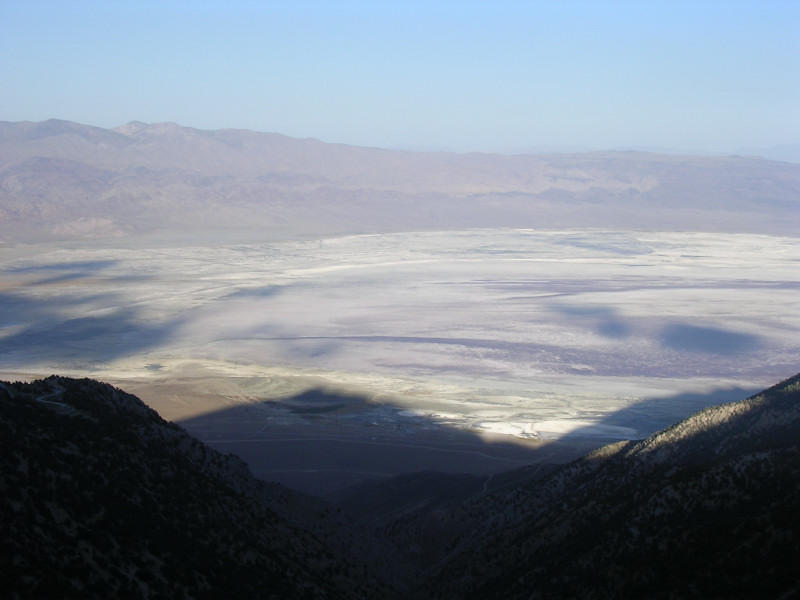
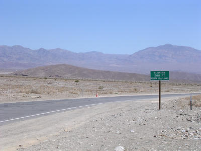
I had a date with the MGM Grand swimming pool in Las Vegas the next day and I hurried through Death Valley, posing to take this photo near Badwater, the continent’s lowest point. Quite a marked contrast from Mt Whitney, eh?
The temperature was 112 F/44½ C.
I didn’t do much in Las Vegas other than to eat and play in the pool. Since this past summer, I have reacquainted myself with swimming, at first at the club, but also in creeks and in the ocean. It is exhilarating, especially when big waves crash on top of you and push you down. I'm turning into a regular gromit with my booggie board.
After the pre-Mt Whiney hikes, I went to soak in Hot Creek near Mammoth. The hot spring in the creek warms the water all the way to the boiling point. I stayed clear of bubbles and chatted the sunset away with an elderly local couple and their visiting nephew, and a young couple from the San Fernando Valley. All had traveled extensively abroad and I delighted in the variety of their experiences. They asked me if I ever feel like moving back to France, a complex decision. My best answer seeks to articulate my profound disappointment at the disintegrating social contract in the United States.
The next day I watched the aftermath of Hurricane Katrina with stupefaction. Already, I noticed inconsistencies between what officials stated and what television cameras showed.
The euphemastically termed delayed response fits within a lack of regard for people without resources. It is symptomatic of those who prostitute the common good for the benefit of the powerful. The House of Representatives was scheduled to repeal the estate tax – a measure of economic benefit for the super rich – and reduce Medicaid payments to the poor last week. Those priorities have quietly recessed from the national debate - if you can call omnipotence that - until such time when the initial outrage wanes.
The social contract withers away. Statistics paint a depressing portrait of the richest nation on earth with entire segments of its population afflicted by Third World problems. We top all Western democracies – and more and more even impoverished countries – in our failure to address a host of social, economic and health issues.
Poor people cast away in the wake of a natural disaster upset our numb acquiescence. For now, the glare of a public (temporarily) disgusted leaves us no place to hide comfortably.
Our system breeds contempt. We are the most unjust and unfair developed country. In the face of our pervasive religiosity, it is a peculiar realization.
We worship this construct.
I am pained by this latest example of our inhumanity. In many countries, this level of failure results in a parliamentary vote of no confidence in the government, which in turn may dissolve both chambers, reshuffle cabinet posts or resign. The political winds shifted violently during the height of the crisis, but already I sense the return of our collective adoration of the existing power structure.
Where was I?
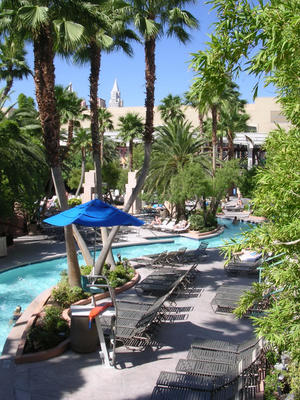
Ah... The MGM has three pools and a meandering river. Notice the Chrysler Building in the background. I got myself an inner tube and floated lazily, cocktail in hand.
I was in Las Vegas a few months ago to do an article on quality entertainment, culture and dining. If the link doesn’t work and you want to read it, I have created another post on this blog.
By and large, Las Vegas sucks, but it also hosts the amazing Cirque du Soleil shows, spectacular restaurants and a nascent cultural stage. The Cirque du Soleil productions bewilder. See “O” if you can only see one. Then indulge – and bring plenty of cash – in a world-class eatery. Definitely worth checking out!